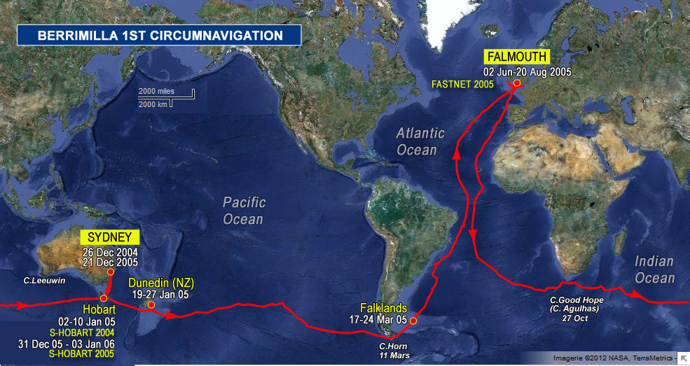
about 30 nm SW of Stewart a black black night except for phosphorescence – more on this later perhaps – in cold driving rain creeping past nz and probably wont sight any part of it – did they move it after all?
Just had a big wind change that left us pointing directly at S. I. so had to gybe back to miss everything, cold and wet and on this tack we need the cone of silence down to protect the nav table and the electrics. a nuisance but essential. C.o.S is heavy plastic curtain that rolls down between nav station and companionway to prevent rain, spray and dumpers from destroying all these goodies. We must be absolutely meticulous about this else pearshapedness in buckets ensues. Having just come hooning into this relatively narrow passage between islands and rocks, i’m even more in awe of the early navigators in ships that were clumsy and difficult to tack and doing it all on dead reckoning. must have closed everything down at night and waited until daylight whenever they were this close or unsure of where they were. Te depth sounder says 599 feet which means that e are crossing the 200 mtr contour, as the gps confirms.
Landfall – sighted the Snares 15m to stbd @ 1730UTC 16/1. Looks as if your preliminary check of our compass has worked, Don. About 8 hours under a week, from memory. Suffering from the warm creamy glow induced by a celebratory Consultation. Still 35 miles to the official waypoint which is beyond the line from S. Si. to the Snares.
Hi Teena, thanks Brian – interesting.
 The logs ramblings can be cryptic, so we have added: