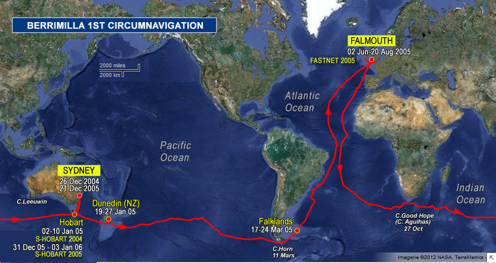
0700hrs 31 Jan 2005 SYD time 49’43”S 179’27”E Map Ref 36
This morning at daybreak we passed 4 miles south of the Antipodes islands – craggy and bleak with vertical cliffs and their own cloud system. I had a feel for how it must have been for earlier navigators on dead reckoning as I peered into the rather murky dawn looking for them and rather wanting to miss them. A couple of hours earlier and a square rigger even reasonably sure of its position would have had to slow down and wait for daylight. They don’t appear on the small gps world map, but Cmap has them, and – relief – in the correct place. The main island is about 4 miles long, looks from the south as if it would be pretty hard to land on from the sea. Looks the sort of place NZ would turn into a wildlife park or a special breeding ground for endangered thingies. Anyone out there know? Do they have a history? And we are 19 miles and about three hours from the international dateline @ 180 degrees and Australia’s yesterday. Milestone # 2 and a must for a visit to the doctor. Bacon sando under way as I write – solo effort as pete is 30ft under and snoring.
Would someone please tell Lleyton that we listened and we think he done real good. He’s our Hero For The Day (and for tomorrow too, as he gets the extra dateline day)- usually, Our Hero at consultation time is someone like James Cook, and Mrs Cook for being stoical in adversity, and Jeanne and Hilary and Steve for being out there too.
Strategically, we are still under the bottom of the high but there is a whiff of a cold front behind us. If it ges folded south by the high, we’re in good form, but just in case it doesn’t, we are creeping north so that we dont have so far to run if it tries to swipe us.
Simon at digiboat, if you’re one of the hitters, where are the past track data files stored? I’ll try and drop them into the gigastik for you in instalment saves and post you a cd from the Falklands.
Next report from Australia’s past. Probably part two of windvane artistry – the clever bit.
 The logs ramblings can be cryptic, so we have added: