Sitrep: 2315hrs 02 Mar 2005 UTC 54’45”S 097’59”W Map Ref 94
Gerry, any comments? As this matters a lot, I’ll post a public correction if this bit of sticking my neck out is wrong, so watch this space…
We’re putting theory into practice. For three years or so, I have been delivering the Safety and Sea Survival course for Yachting Australia. Most of it I can talk about from experience so can get by amongst the more experienced yachties on my street creds, but one of the topics is about avoiding tropical revolving storms (TRS) – cyclones in the vernacular. As a wise old sailor who never goes north of Lord Howe Island (except to play with Mike Job on Moreton Bay and that doesn’t count), I’ve never been near one in a boat and I’ve always wondered whether the standard technique for avoidance is a) easy to apply in practice and b) actually works. So here we are deep in the southern ocean, not a real cyclone in sight but a tight little depression of unknown nastiness behind and catching us somewhere and to be avoided or at least mitigated. No real difference in the actual problem, although possibly a big ferocity is factor missing down here. So, if you are out in front of the TRS, the wind will be somewhere from the north to the south east depending on exactly where you are relative to the path of the TRS and the technique for avoiding TRS in the southern hemisphere goes like this:
1. Establish where you are relative to the path of the TRS by applying Buys Ballot’s law (all the ‘L’s) L ook into wind. The L ow will be about 90 degrees on your L eft (actually just a bit more but inconsequential) 2. Monitor the wind direction over time. If it is backing, (its direction changing anticlockwise, or from say north east to north) you are in the dangerous NE quadrant. If it is veering, you are in the less dangerous but still very iffy SE quadrant (remember my diatribe about lows and plugholes a week or so ago?). This is a hard concept to visualise in the classroom but is pretty obvious out here, as I’ve discovered. If the wind is neither backing nor veering, you are right in the path of the TRS. The barometer will be falling also, and this may indicate just how far away the nasty bit is.
3. If backing, steer to put the wind fine on the port bow and sail to keep it there. If veering, put the wind on your port quarter and keep it there. If neither, put it on your port beam, ditto. Each of these will take you on a broad semi-circle away from the centre of the TRS, the first to the north and west, the other two the south and west.
So:
There we were in a strong northerly wind earlier today knowing from the grib file that there’s a tight little low to the south west. Buys Ballot says that the low is directly south west of us and the wind was very slowly backing, confirming that we were just north of the path of the low. Easy so far. Solution – put the wind fine on the port bow. This we have done and we were heading north east with Kevvo steering to the apparent wind, so keeping it in the same relative position. We have watched the first lines of cloud pass overhead and we can see the cloud building up bigtime behind and to the south west of us. As the system has approached us, our heading has gradually changed towards the north as the wind has backed further and Kevvo maintains a constant apparent wind angle and we would now expect it to go further towards the west as we move to the north and above the centre of the low.
So it seems to work. As it’s not a TRS, we’ll probably keep going vaguely north east till we can test the wind strength and direction closer to the centre and then we will decide what to do – probably a westerly wind around 35 knots so twin pole set to the east, but which sails to set will depend on the wind strength and the wave height and characteristics. Big wind, building waves, possibly breaking – small sails and v-v. Hope it is reasonably soft and lasts for a few days.
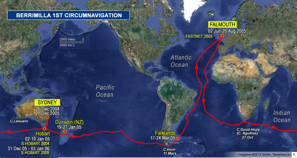
 The logs ramblings can be cryptic, so we have added: