0920hrs 22 Oct 2005 UTC 39’39”S 014’36”E Ref 472
db: dmgDistance Made Good; More here
114, gps 106 (crashes) day’s run 101 – all looks a bit fishy. 63/47 – also looking a bit pear shaped. these storms were not in the equation. short burst of unshine – wind temporarily back to 30+. managed to get the gribWeather files.
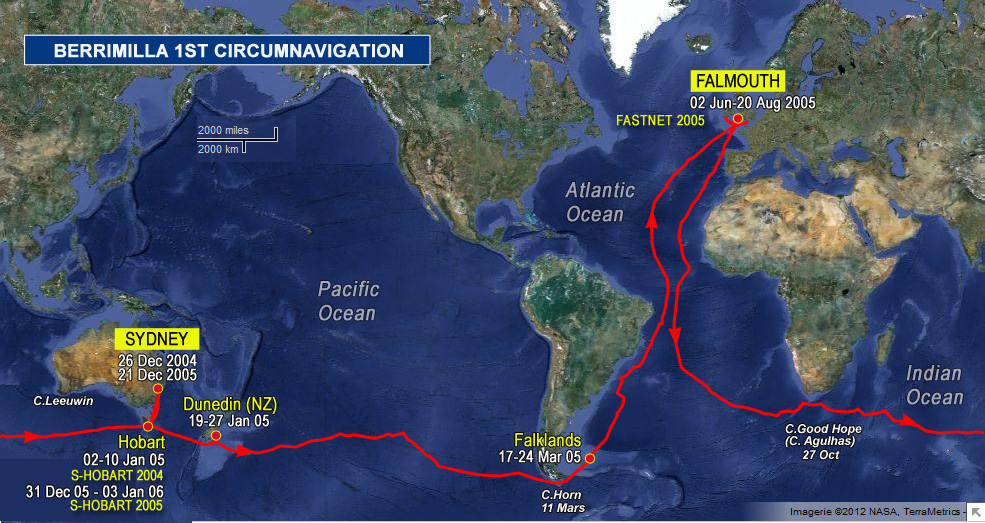
Graphics in Binary file: GRIB files associate a specific weather datum (eg wind velocity or atmospheric pressure) with a geographic position. Because the resulting file is a collection of these points they are extremely small and so ideal over slow links such as sailmail. – three more days of this followed by a high cell. unpleasant prospect. surface of sea has huge moving white patches, massive wind lines, horizontal spray all glistening tn the sunlight. consultaation was very welcome this morning. wendy p, we’re saving your specials – cape agulhasThe southernmost point of Africa, where the Atlantic meets the Indian Ocean. The real corner, south east of the Cape of Good Hope., half way across, cape leeuwin, se capeThe southernmost point of the main island of Tasmania, iron potA small island lying close to the south-eastern coast of Tasmania around the entrance to the River DerwentThe Derwent is a river in Tasmania, Australia. Its large estuary forms the port of Hobart.
. It is the site of Tasmania’s first lighthouse.. will report. waves shorter and steeper than cape horn – not as high – more savage and destructive, if that’s possible.
 The logs ramblings can be cryptic, so we have added: