|
|
||
|
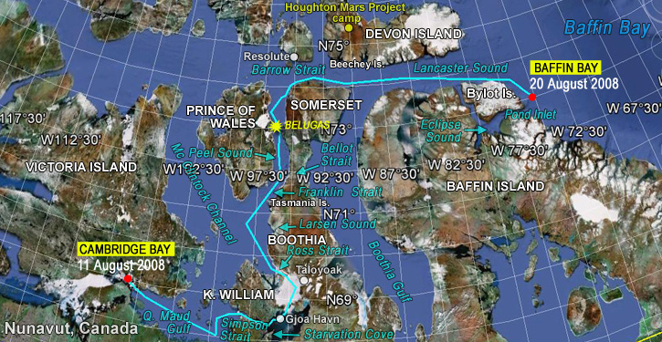
2-7. Cambridge Bay-Baffin Bay
Track
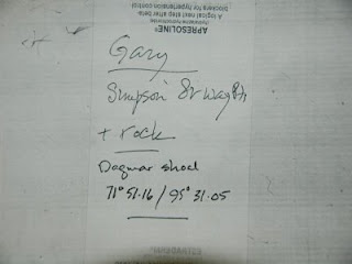
Logs ( 45 )The easterly has really set in and we have decided that an all night headbang to gain perhaps 20 miles is not sensible when the wind is due to go westerly tomorrow. Pic shows co-ordinates of one of the little hazards on the way…
Departed CB 1030 – about 3.5 days to Taloyoak if we get lucky and then we have to eyeball it. May be a longish wait – at anchor too, so possibly uncomfortable. There's still a lot of ice in Franklin and these westerlies will tend to keep it there, although they should also apply some heat and perhaps accelerate the melt. Tricky passage through Simpson Strait south of King William Island and towards the end of it we will cross the path of the last Franklin expedition survivors, on their way over the ice to Starvation Point, where it is believed they all died after eating the bodies of their dead colleagues and being unable to catch bears or seals and anyway not understanding that that way – perhaps – lay survival. Thanks to Corey for his hospitality and help while we were in CB, and to the RCMP for being cool about our unorthodox arrival. And to Matt for playing around with google earth. ———- Out in the middle of Maud, where, 2 weeks ago, there was ice. Water milky rather sludgy emerald and a balmy 8 degrees. Kevvo0 back in charge – his stainless brain the size of a planet is not fussed by magnetic anomalies. We've been astonishingly lucky so far with both wind and ice but that may be about to change. If it does, the level of risk increases daily that we will not be able to cross the 25 mile stretch of ice in Franklin that may be all that is stopping us from getting through. And if that happens, we have to get back to somewhere safe before the sea starts to freeze again and the temperature to plummet. In that case we would try to get back to CB with Gjoa Haven as a last resort. Lots of factors – for instance, we can possibly lift Berri out of the water in CB. We're not short of advice – I am talking on the radio twice daily with Peter Semotiuk in CB – legendary sailor and helper of yachts in the NWP – and with Amodino, Arctic Wanderer and Tyhina, who is in Resolute and heading west. Also talking once a day with Pat Hahn in Nome on the satphone to get his take on things. ———- Its all getting terribly exciting… the distances from here are now quite small (in terms of taking the journey in small manageable chunks of legs, so I mean for the rest of the NWP bit!!!), as we are so far north- we are only 12 miles south of the western tip of King William Island… 20 miles to the start of the Simpson Strait, which is only about 30 miles long for, less than 100 to Gjoa HAven, less than 200 round to the northern tip of King William Island, barely another 100 miles to Bellot Strait after that and 400ish to Resolute… oh but, yeah, a lot of that is, er, ice… really unhelpful!!! Its weird that there is effectively a 'wall' of solid matter stopping us… you don't normally go sailing somewhere not anticipating that you might not actually get there- unless I guess you are trying to sail to Switzerland!!! (incidentally and totally irrelevant, I got asked by a random in Nome if we had sailed from Switzerland and he meant it earnestly) And its entirely in the hands of the wind and ice gods now… we must be nice to them, so they change their minds about the norwesterlies forecast for the rest of the week!!!! ———- We passed 9000 miles since Sydney, crossed 100 deg W and are now in Franklin territory. EErie. And, as McQ says -soooo near and sooooo far to go – about 25 miles of ice… We will probably stop in Gjoa Haven for a day or so to do a couple of fixes and watch the ice. ———- Alex and all
This morning's ice report shows 2/10 or better the entire Ross to Franklin bit. Mostly 1/10 or open! Major upgrade!! Skip long stay at Gjoa Haven and go on to starvation point. (I really hate that name) Around the west side of King William. The front door, up the middle of Maud is still closed, back door is open as you planed. A large Gulf of Alaska front just over the Rockies into the Yukon, 2-3 days to hit you as it goes past it will first blow west, than turn to southerlies. (my prediction, so take it lightly) You are in for a couple warm clear days until the front hits. This thing should blow you right up Peel and out Lancaster. I would try to get through the ice before this front hits. I love armchair sailing! Take care. Pat We are 11 miles north of Starvation Cove where the final group of the Franklin people are believed to have died. In the last half hour, we must have crossed their paths over the ice to get there. No-one knows how many were left or who they were – a few, emaciated, ragged, frostbitten men carrying the desperate hope that they could find help or get to a settlement on the mainland. There is evidence that they made camp at Starvation Cove and got no further. They have been given the credit for actually discovering the North West Passage by crossing this stretch of water, although they did not know that they had. Some 50 years later, Amundsen proved it. I feel almost ashamed that it has been so easy for us to get here and deep sadness, respect and a sense of the heroic futility of it all for the Franklin people. Expectations, imperial politics, mistakes at all levels and a failure to learn from them and ultimately disaster. May they rest in peace and may the cruise ships never ever come here to disturb them. And, perhaps, this is our first real link with the other side – a crossing of ways and a small achievement even if nothing else works from here. ———- If such it could be said to be – we should be in Gjoa Havn this afternoon. The ice and weather are not looking at all good in the short term so we will wait in GH and see what happens. Options are to go back and look around the western and northern sides of King William and see whether we can get through to the west, or to nose out into James Ross Strait and feel the ice, or just to sit and wait for an easterly storm to open up a lead for us. If none of these, then we will have to park Berri somewhere for a possibly 50(F) below winter. I don’t know what facilities there are in GH, but I think that we might be able to get her out of the water in Cambridge Bay so contingency plans are hatching for any or all of the above. Appendages please – it’s early yet but not looking too rosy. If it all goes pearshaped, we will aim to be back in Cambridge Bay or GH by the end of September at the very latest. ———- I just talked to Alex on the sat phone.
He just received my "It's open" message. First my apologies; I write from memory as I have no names on my maps. Starvation cove is the south end of King william, not the north point as I thought.
Alex was very excited about the ice report. The full length of western coast Boothia is open or very thin (East side of Ross- Larsen- Franklin). The Berri is going to skip Gjoa Haven and move up into Ross for the attempt.
Gods speed.
Pat
Seems there may be a die to be carped so we'll go carp. Fallback will be Taloyoak or back to GH. Wish us luck and cross 'em! ———- If Peter Semotiuk, reads this could he please contact me through the contact tab on the website. I have had a request from someone for his contact email. Thanks, Speedy. Alex,
The big picture; the pacific 'arch' is back in classic form. Gulf of AK up to Coronation/Maud and back down mid west and East coast. These are the same conditions you know and have come to love. More heat and moisture. You may loose the westerlies as you move north above the King. Larsen appears to be above the 'arch' so local conditions will prevail. The bad news is new ice is forming in the northern areas above Resolute and way above Barrow. One can play 'chicken' with new ice at this time of year, but sooner or later the new ice will win.I don't expect any new ice to stay. All that ice in Larsen is spreading out. That means it is about to self destruct. I think your position and timing is about perfect. CB 10Degrees,ESE 17 kmh Is it possible to send you an ice map by sailmail? Will it crash your mail? It would be very helpful navigating Ross Larsen Franklin. Pat Just talked to Alex, The Berri is just above Matty Island in the middle.
They talked to another boat coming south at the other end of this ice gut and the report is open ice.
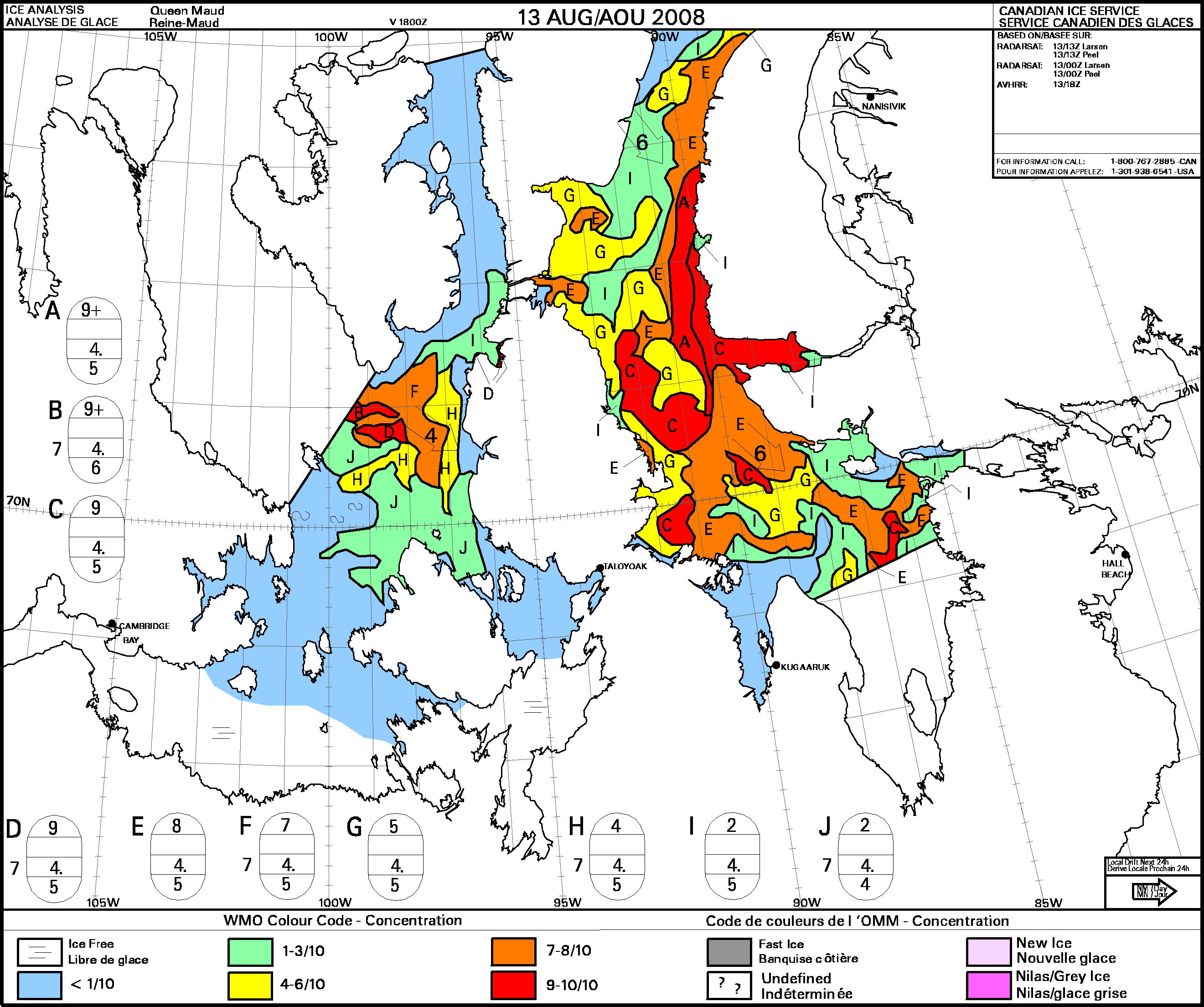
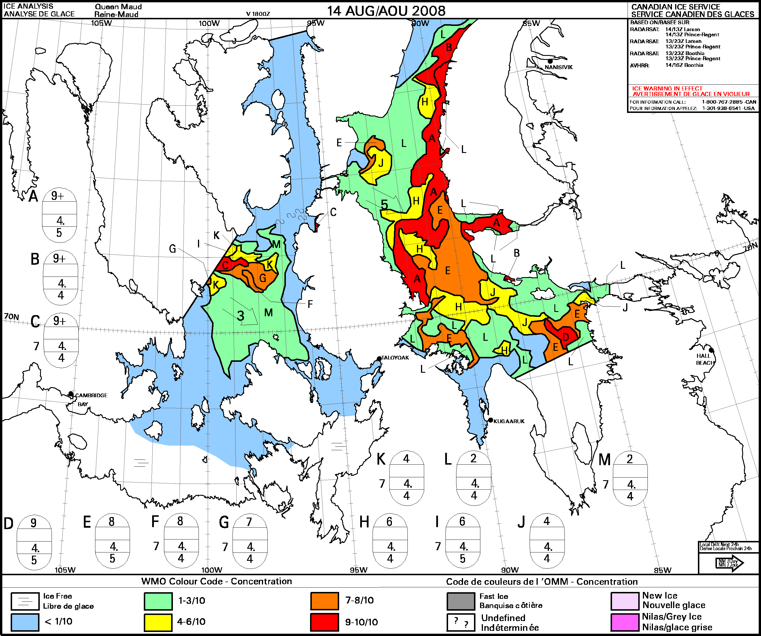
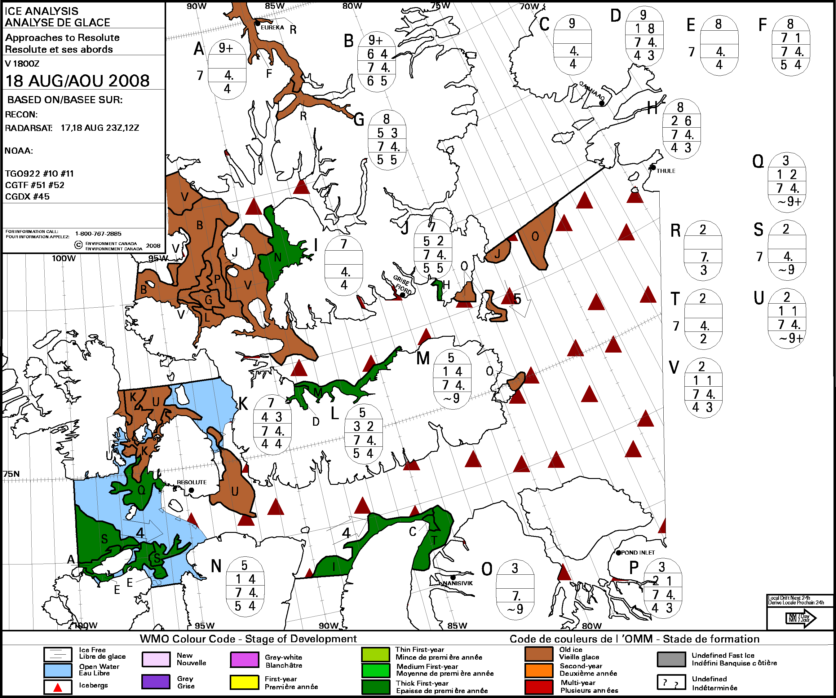
Ice continues to dissipate. Green is still good. The Berri strikes out. We turn blue holding our breath. Fingers crossed. Knocked on wood.Newest ice map
Ice map courtesy of the
Canadian Ice Service Radarsat 14 Aug 2008An ice warning is in effect. 1 800 767 2885 Can 1 301 938 6541 US Alex
I've just looked at the past year of ice charts. Freeze ups in maud not until Oct last year. serious freeze in mid Oct.
New Ice has two unexpected dangers. The first you know, we have all seen it on fishing boats as the ocean spray freezes to the deck, lines and everything. Call out the tough guys with sledge hammers in each hand.
The second real danger is young ice formed on still water can be reasonable fresh (no salt).It freezes hard and thin and acts like a knife to a tinder boat, cutting at the water line. We used to carry tarps to hang over the front to protect our walrus skins. You may see freezing as you move north…
Todays map, one year ago, looks surprisingly like today. As the fall weather deteriorates, so goes the ice. Then in Oct. it freezes overnight. The Berri has a couple weeks grace if you don't mind autumn misery!
The ice continues to look passable. The Berri is above the pacific weather 'arch' and below the arctic lows. I would expect confused wind.
Pat
Alex called at 7 am our time (9pm UTC, I think) to say that they are in the narrows north of Matty Island. It is flat calm, water temperature 3 degrees and they are motoring. In the next 24 hours or so they will have come to probably the worst of the ice and know whether they have got through that part. The not so good news is that the previous night, new ice formed, but I’m not sure where. 
Thank you to the Canadian weather service. The purple is the new ice from the evening 13th and morning 14th, and the first I’ve seen this year. Pat Alex,
I hope you are making it through the ice gut. I'm afraid the lows at the north pole will cause you some NW wind. Bummer for going up Peel, but should be a help in Lancaster. Snowing at Resolute and expected to continue for a few days. No ice warnings yet today, but still early. Some loose ice blowing in at the western top of peel, best to keep right up there. Pat Alex just called by sat phone
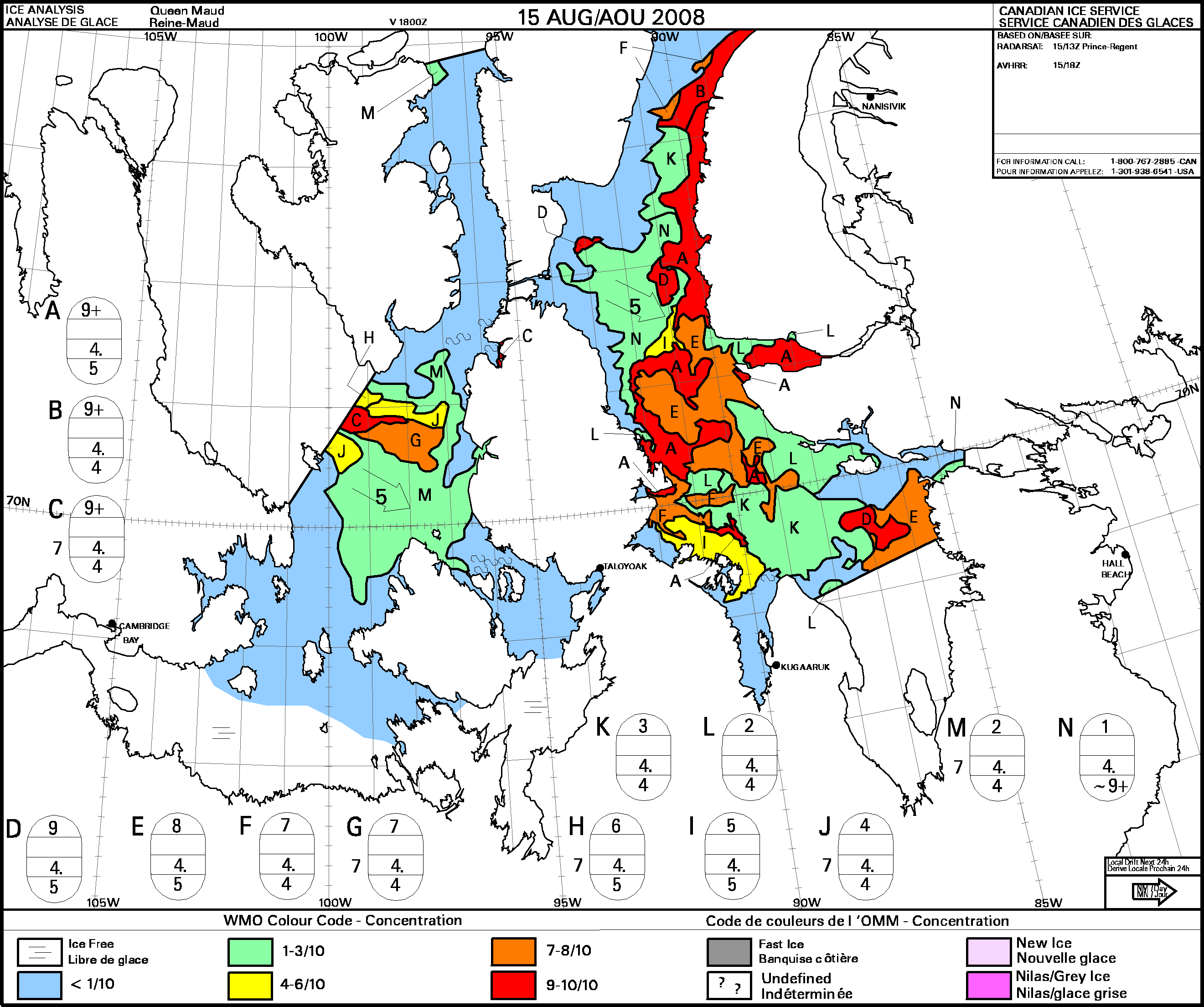
The Berri is just below the tip of the Tasmania Islands. Ice all around, "it's a wall" but they can see one small opening to the NW. That is consistent with the ice charts and so that is where he will be heading. Fingers still crossed, just knocked on wood. If I thought throwing salt over my shoulder would help, I would go home and do it. The Amodino is stuck in the ice. They are much larger and can hopefully push their way around. Good luck to them. The Berri is too small and under powered to help, if there was a prayer to get close enough to help. I saw a small oil tanker with a bent propeller and shaft from the ice. The shaft was designed for the arctic and was several feet (1Meter) diameter. This is scary stuff. Ice this dense,1/10 to 2/10, doesn't just float around, it plays bumper penguin. One moving piece bumps into the next stopping but causes the next piece to take off, and so on. Openings close quickly and new opening happen just as fast. It's hard enough in the daylight, just try it in the dark. The unlucky boat gets caught. The really unlucky boat gets damaged. You really have to stay on your toes. Add land and the ice stacks up with a continuous buildup. Extreme buildup causes pressure ridges and kills ships. Today's ice map similar to yesterdays so will not post. Pat PS Alex can correct my over dramatization when he has a chance. It’s too much fun watching these maps. Note the ice at the top right corner of peel. Sneaking in. There’s more behind it. The Berri is to the right of the “M” in Franklin St.,trying to sneak out. The blog will cut off the credit so thank you to; Canadian Ice Service Pat If it's white or Colgate blue it's probably ice. Often looks like a solid line on the horizon, but often has gaps on closer inspection. Dodge. If it's very small, pointed and dirty grey it could be a Northern Fulmar (ie: bird). These can fly, so no need to dodge. If it's very small, triangular shaped, splashing and dark grey it's probably a seal. Wave exctaticly. Been going in and out of icy patches all day. Very foggy & spooky last night – perfectly calm, no horizon and no sense of perspective. Alex likened it to being suspended in a glass of milk, which was pretty close! Spectacular National Geo cover beautiful stuff at sunrise this morning. Add some penguins and it would be per-wer-fect! Passed Tyhina going south about 0500, and another French vessel (Peregrine?) also heading south slightly later. Amadino overtook us in the wee hours and we were in sight of them for several hours. Positively crowded in Franklin Strait today. Just gone through a thick bit of ice, in fog. Ice has thinned out now for a bit, so hopefully fog will do the same. I still hate fog. Water temp has plummeted to a new low and the gauge is hovering between 1.8 & 2.0 deg C. Brrr. Toes officially cold & nose runny. Will be abeam of Tasmania Islands in about 15 miles. Home sweet home! K. ———- After a night of headwind sailing in short choppy seas, we're now just entering the southern end of James Ross Strait in near calm conditions. But it's getting cold! The water temperature has gone down from 9 deg C to 3 deg C overnight, and my (oh so accurate) Alaska key-chain thermometer moved down from 16 deg C (where it's been since I bought it in the gift shop in Nome) to 10 deg C. Hence the Arctic onions – the three of us are all dressed up in layer after layer of clothing to keep the chilly air at bay. Thinking of adding an extra layer, but not sure I'll be able to move around deck if I do! No sign of ice yet, but it's likely to show up later today or early tomorrow. Probably in the middle of the night just to be difficult (it's starting to get dark again now). The yacht Tyhina has come down from Resolute to the Tasmania Islands without encountering too much ice, which is good news for us. So fingers crossed for the next 24-48 hours for the good conditions to hold so we can get north past the "tricky bit" where McClintock Strait dumps ice from the NW into Larsen & Tyhina can get safely south to James Ross St. Hilary – thanks for your kind thoughts. No rosebuds to gather, but certainly an atmosphere of remote and solemn tranquility to absorb. At the moment the clouds are reflecting a rose-pinky-grey above the tundra, so that can be today's shade of grey. Love to all, K. (PS- Mum & Dad – after telling you on the phone the other night that it drizzled more than rained up here, we had some real proper Tasmanian bushwalking rain the other night. After getting soaked by it for an hour or so I decided to make us of it and catch some fresh water off the boom, which was quite a successful way of making it stop raining!!) ———- This will be a very long 36 hours or so for me. Wish I was more like Marvin – or even Eeyore. Tyhina is 78 miles north of us, I think in 2 tenths ice and we should see him in the next 15 hours or so. The sun is shining, there's fog on the horizon and these days it gets dark as well so we will need to be careful if we are in ice. Later 6956 09618 thick fog and we have seen our first bit of ice – all by itself in 5 deg water. An arctic tern somewhere above. Later still 7029 09641 Scary night – complete whiteout – no horizon, no sky, no water – just grey white with chunks of ice and sheets of ice and little bits of ice in the fog. 2 kts and weaving around to get though. Tyhina now past going south. Amodino ahead to starboard and 90 to Bellot Strait. The most spectacularly beautiful dawn I have ever seen. Photos sometime – wonderful. later still – at Tas Island – still lots of ice – Amodino went inshore further south – haven't seen them come out yet. These queuing up – will try to send Later still -7137 096 14 I think we're through the ice – Bellot late tonight agw - ———- Kimbra's right- It is soooo cold!!! Though it looks delightfully inviting, sparkling in the sunlight, the water is hovering around 3-4 degrees, not swimming temperature really!!! The air definitely has that arctic feel about it, even my breath has breath, its that cold!! A couple of hours on deck is just about bearable but then it takes most of the next off watch to warm hands, fingers, nose and toes!!! Even Big A had to relent in CB and borrow a huge thick down sleeping bag from Corey to help warm his toes and just last night I broke out the last layer of bedding, and am now encapsulated in my bunk in cat's meow, various blankets, thermal liners and an Irn-Bru coloured Sea Rug (which makes me happy!!!) The GRIB's are looking promising, if they are right, we are in for a couple of days of lightish westerlies, which may make it possible to get through the next icy bit and the sun is out in full force this afternoon hopefully warming up and melting the ice a little from above!!! Pat's monitoring things for us from (his home, in) Nome and has advised that there is an opening through, so we are on the way, just passing Matty Island now and planning to stick close to the eastern shore of the Sound as we go north, heading iceward!!! Its almost too exciting now!!!! Hope everyone well and warm at home, ———- Short call from Alex,
They have decided “to use Peel Sound over Bellot/Prince Regent Inlet for a variety of reasons” to be discussed someplace other than the expensive sat phone.
Alex gave his position in relation to some island. My tiny brain and poor reception lost it. I think he said “Bear Island” but I only see Barth Island which is consistent to the Berri’s speed. About half way up the west coast of Summerset Island.
Snowing, NW and cold about covers it.
Cold NW winds expected all the way up. New ice still forming around Banks island to the west. A little old ice expected at the top end of Peel… nothing like they have been through.
The plan now is to get the hell out as fast as they can.
This type of cold chills to the bone and I considered worse then -40. I used to wear my best winter gear to stay warm.
Pat
Breakfast entertainment in Peel Sound. There were about 6 belugas around the boat one came right alongside and lots of seals – brown heads, greyish mottled bodies, quite small. The porpophin was small, grey green brown – hard to tell – with a small fin. Fulmars and tiny petrels. And Kimbra had porridge. We decided not to go through Bellot last night – the depth sounder dropped out of the instrument system and it was windy and murky to boot – so we went north. Later – 7303 09553 0- headbutting a light northerly to try to get out of Peel sound and turn east at last. For the very first time, I'm starting to think that Pascal might have got his map right. Sorry these so short and dull. Hand steering and sleeping at the mo and doing all the other necessary stuff and a bit ragged. ———- You've heard of gorillas in the mist, but today we've had belugas and snow! I've never seen a beluga whale before, but I have to say it was love at first sight. To me, these small whales are superficially more like oversize, white, friendly dolphins. As Alex said, we saw a small, loose pod of about 6 belugas around brekkie-o'clock this morning. One appeared to be stalking us, so maybe word has got around the whale-world about Corrie's close encounter off Barrow and they're out for revenge? Anyway, most cool! The weather is also (still) most cool. So far, it's snowed on 3 separate occasions today. My Alaska keychain thermometer is still telling me it's 10 deg C, but I'm rapidly losing faith in it. My cold-toe-ometer is telling me that it's probably a little less than that. Cold enough to break out the hot porridge with dried apricots and maple syrup for breakfast. Yum. While I hate fog, I'm really kinda fond of snow. There's not enough of it (yet!) for it to settle, and we're definitely not talking snowmen either, but it's very peaceful. And makes a nice change from the rain. It's starting to settle on the hills bordering Peel Sound, and dusting parts of them a light grey against the dark blue-brown rock. Nearly around the top of Peel Sound. Another 50 NM until we hang right and turn east along Barrow Strait and Lancaster Sound towards Greenland. So 50 NM to go to my mental halfway point, where we stop heading away from the edge of the world and start heading back to civilisation. Anyway, my fingers are too cold to hit the right keys on this miniature keyboard, so I'm heading for my bunk. Wake me for dinner in bed in an hour or so…wonder what Corrie's cooking tonight? Night all! K. ———- Snow, snow, snowety, snow!!! woo-hoo!!! ———- As Pat said, it certainly isn't. I take a very much dimmer view of snow than the other two – it is potentially lethal out here if the temperature drops a couple of degrees and it starts to freeze on to the boat so I want it to go away. Now! Not much chance, I'm afraid – the forecast is for 3 days of it. And we're headbanging into a nasty northerly with wind waves that just about stop us so very slow progress all motoring. I hope the engine keeps behaving. I've just sucked about 10cc of brown sludge from the fuel tank so that at least won't get to the filters. Keep em crossed. It's still hairy. ———- And now we have ice – not too serious but a lot of it all around us. Blue, old ice in big lumps. Heading direct for Limestone Island – just visible 9 miles away in the murk. Later – a warm coffee inside me and 10 miles or so closer to Falmouth – we have the entire north west coast of Somerset in sight and it's breathtaking, if you'll excuse the cliche. Gravel beaches, glaciers, shore ice Brownish white, bergy ice around us brilliant Pacific Ocean blue, hills in the background smooth snow. The cliffs and slopes behind the beaches are all ice and water eroded just like google earth showed me all those months ago. How ever did they fined a clear day for the google earth images? As for clothing I thought a detailed list might be informative. On deck, I wear my brown fisherman's super tough wellies, aka Sitka Slippers, with sock liners and fleece socks. Glove liners and insulated industrial rubber gloves. From the skin out, a thermal vest with long sleeves, T shirt, no knickers or thermals over the nethers (because they promote the most agonising gunwale bum) so a fleece mid layer known as salopettes, with a fleece hoodie on top. Sometimes a balaclava and neck tube. On top of all that, a Mustang survival suit or a float coat and Henri pants if it's not too cold. Goggles if it's snowing or windy. We are about 50 miles from Beechey, where Franklin spent 2 winters (I think) and where Torrington, Brayne and Hartnell are still. Sadly, there's no chance we will be going there – all the signs say get out of here as fast as possible. More on this later, but we have been astoundingly lucky so far and I don't think we could have got through a day earlier. If all the six or seven boats that we know about get through this year, there will be a hundred trying next year. For their benefit, I think I should say loud and clear that it isn't as easy as it might look. It has been the most difficult thing I have ever done – makes Cape Horn look like a jolly by comparison – and we have done it in an easy year. If just a couple of things had gone the other way, we could have been in very serious trouble – and we're by no means on our way home yet. ———- The three arctic onions have morphed overnight into abominable snowmen. The layers and layers of clothing (I'm wearing 28 individual pieces of clothing on deck at the mo') have been covered with a fine layer of slushy snow. And we were joined in the wee hours by a new crew member – Doris, the world's smallest, slushiest snowperson. Sadly, she decided not to hang around and disappeared off to wherever snowpeople go when they melt. I seem to have lucked-in on the on-watch visibility. When I came on deck at 0500 it was to the view of towering limestone and ice cliffs at the northern end of Somerset Island. Wow – pretty spectacular stuff. Don't think a camera will ever do it justice. Still quite a few bergy bits around the place – nothing too serious. And I have a new definition of a following wind: a headwind that follows you around every bear-away on the route so that it continues to be a headwind. Grr… It's currently stopped snowing. Alex's somewhat more accurate watch-thermometer is reading an air temperature of 1 deg C, so let's hope those grey clouds don't catch us and dump too much more snow on wee Berri. On a somewhat more serious note, it's very sobering to remember that in the last 3 days we have travelled the same route (in reverse) that the men of the Franklin expedition spent their entire last summer alive traversing. By comparison we have it easy: someone has already charted the waters (who knows how many dead ends they followed before getting to King William Is), we have electronic navigation systems, grib files and marine weather forecasts, satellite produced ice charts, diesel engines, good food, polar fleece & gortex clothing and, I suspect, a lot less sea ice to deal with (global warming or mere good luck?). K. ———- Hopefully we won’t see to much of Lancaster.
Last reported location is to the right of the red/ green combo. Rounding the corner into Lancaster. The Berri beat the ice moving across the north mouth of Peel.
Now it’s ice berg watch. Big nasties all the way to greenland and beyond.
Flat ice moves to the ‘will’ of the wind, bergs move to the ‘will’ of the current. It makes for an interesting tail of flotsam. Like a comet.
The prince Regent squeeze would have been interesting. The ice looks like a little yellow Pac Man about to bit anything coming through.
Just off the sat phone with Alex,
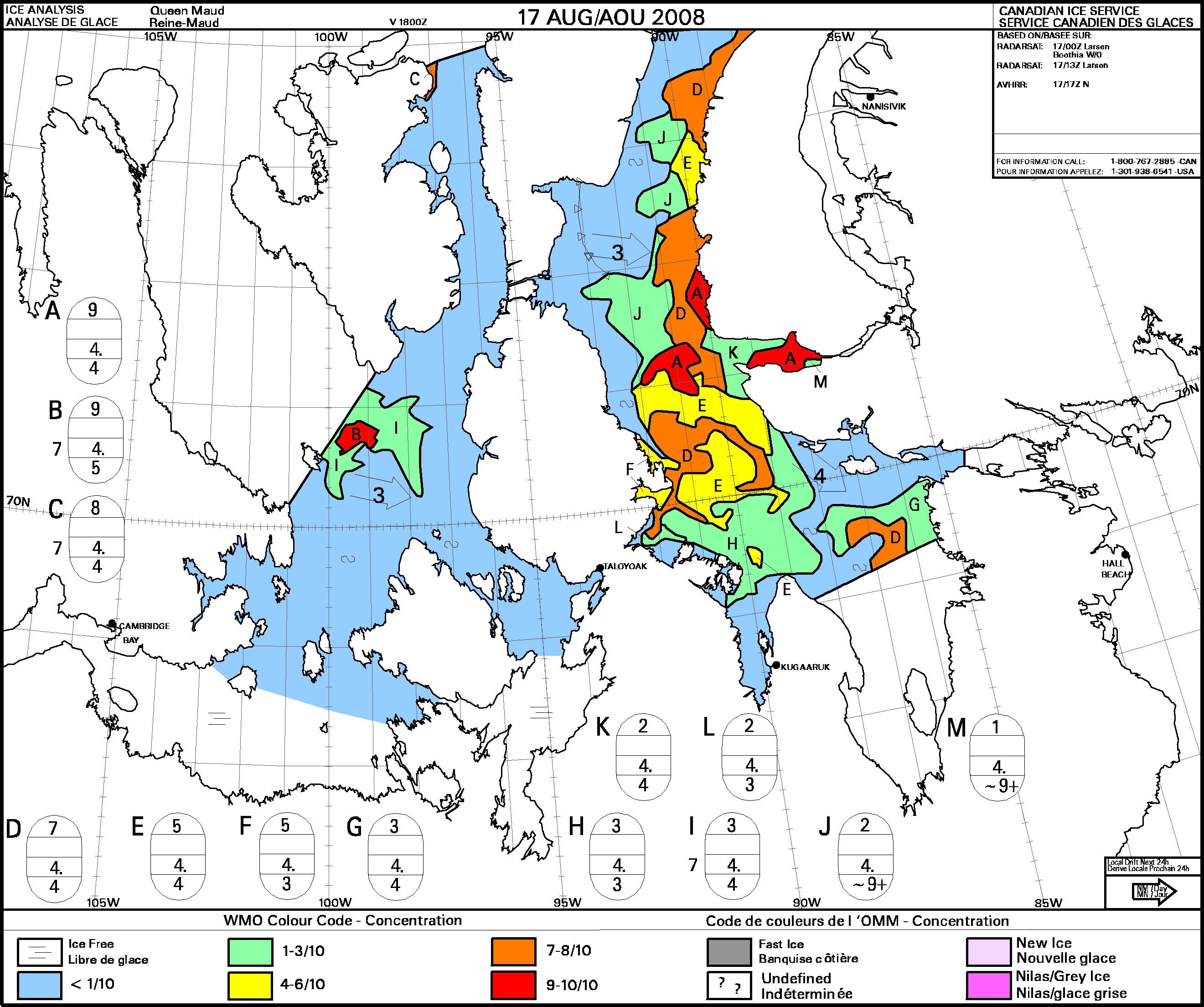
The Berri is center over the top of Summerset, hugging the coast heading ESE at the moment. They are out of the ice for now. Snow was a bit of a problem when it started to freeze on the deck. They are past that now. There is a large weather system sitting on top of Ellesmere Island spinning counter clockwise pulling cold arctic air down in its arms. There should be good westerlies on Lancaster for as long as that system continues. The Atlantic is a mess from the Saint Lawrence seaway to France. It never ends. You can check out these maps on; Canadian Ice Service or Environment Canada. Pat oh how I wish the oreo cookie monster would leave me alone!!! he hangs out shivering at the end of my bunk while I am off watch, desperately trying to ignore him, though its hard as he looks so blue and fluffy and unmonsterlike and pathetic, then when I come on watch he sort of attaches himself to me and won’t leave me alone, till I relent and eat cookies, despite my constant protesting!!! To jump on the clothing bandwagon too, which i think I just win, I have on: Oh how I sometimes wish the oreo cookie monster was a heater instead, then he could hang on to me all day and night long, and I wouldn’t mind at all!! Hope everyone well and warm ———- Kimbra’s watch and we are almost as far north as we need to go to round the northernmost point of Somerset Island, just east of Cunningham Bay. So – in an hour or so we should be able to head east, then south east. No more ice visible, Cornwallis just there on the N. horizon and a lighter patch of cloud where Beechey should be, about 45 miles away. Worth just a tiny wooohooo! Pascal’s dotted line is ok so far – we can’t test the Beechey bit but we’ll pick it up again soon. As for clothing I thought a detailed list might be interesting. On deck, I wear my brown fisherman’s super tough wellies, aka Sitka Slippers, with sock liners and fleece socks. Glove liners and insulated industrial rubber gloves. From the skin out, a thermal vest with long sleeves, T shirt, no knickers or thermals over the nethers (because they promote the most agonising gunwale bum) so a fleece mid layer known as salopettes, with a fleece hoodie on top. Sometimes a balaclava and neck tube. On top of all that, a Mustang survival suit or a float coat and Henri pants if it’s not too cold. Goggles if it’s snowing or windy. And it has come to pass – at 1750 UTC Sunday August 17 we turned east, then south east at 74.12.10.3N 093.57.28.2W. Half way Consultation is occurring. Slightly bigger Wooohooo! And keep ‘em crossed please. Looong way to go yet. ———- They got out just in time. Resolute is freezing in behind them.(M) Its shortlived, thin new ice. The worst kind to a small boat.
The system centered above Ellesmere has swung down around to the behind the Berri. Winds should be W and SW. Storm warning to the south. Lancaster and Baffin should be OK. Ice in the center of Baffin is down to two small holdouts. (And lots of big bergs) Credits to Environment Canada, Canadian Ice Service
Talked to Alex an hour ago.
The Berri is over the top of Borden Island. They plan to duck into Eclipse sound, under Bylot Island, in line with Pond Inlet. All this is, of course, the top of Baffin. The weather system coming in behind the Berri is bringing a lot of cold with it. Forecasts are as low as 6 below C. It has got to feel good to be out of Passage!! I'm not quite sure where the start and finish lines are, But I would say the Berrimilla and fine crew are on the "I did it" list. There are two rounds of toasts to be made. One for the Northwest Passage now and the other we will save for a safe return to Australia in the near future (via UK). The Berrimilla is the first boat to complete the NW passage in 2008, beating the Amodino by one day. (YAAA!!!) (I guess the Amodino got out of the ice OK back in Peel) I believe the Berrimilla is the first Australian boat to complete the NW Passage! (YAAAAA!!! CHEERS! homemade Coopers in the air please!!!) I believe the Berrimilla is the only boat to circumnavagate the world by the Horn and sail the NW passage. (YAAA!! CHEERS! Guinness if you ran out of Coopers) Congratulations to Alex, Corry, and Kimbra!! Not too much coopers please as there is still a long way home. Pat Todays ice map greatly improved over yesterdays. The two little ice islands were connected and much bigger. Pat Amendments to the BVS for your BVS reference notes: Lots of love on this frosty but stunning morning!! ———- For the last day we've been sailing along the southern edge of Lancaster Sound, quite close to the top of Somerset Island, Brodeur Peninsula, Baffin Island and now Bylot Island. We've seen some textbook-perfect geological features along the cliffs as we've gone past: U-shaped glacial valleys, some with small active glaciers; deeply etched V-shape notches cut by meltwater; crumbling talus cones; sea cliffs undercut by water and ice; and stripes of horizontal sedimentary layers with the odd fault line and inclined bed. All raw and uncluttered by vegetation – just a gentle dusting of snow to bring out the grain. Stoic fingers of land cradling deep, icy runs of water. Absolutely perfect. The dark-layered cliffs on the north of Somerset looked a lot like a layered chocolate mocha cake, with a light dusting of sugar. Moving further east, the mountains increased in height and the icing-sugar dusting deepened into a thick, rich layer of carrot cake frosting. Mmmm…maybe that self imposed chocolate-free 24 hours wasn't such a good thing, I'm starting to hallucinate about rocks and dirt! But to continue the theme, it was snowing again when I went off watch – nice, dry, eyelash-tickling flakes, so the frosting on the land is getting thicker. We also saw our first proper iceberg yesterday, north of Somerset Island. I reckoned it was about 300 m across and 15 m high. Alex's estimate was slightly bigger at a bit less than 1/2 a mile across and 20 m high. Corrie won't tell us her guess – it's "the one that got away" size, so it sounds impressive in her diary! Anyway, it was the first berg any of us have ever seen, so it's probably one of the most photographed bits of ice in history! We've seen a dozen or so of various sizes cruising though Lancaster Sound since. Their size is deceptively hard to judge as there's not much to use to get a sense of perspective or scale. All in all, it was a fine old day. 50 odd miles to go before we can turn the corner, wave goodbye to Lancaster and enter the Baffin Sea. We've got fickle, light-ish headwinds in the lee of Bylot, with a lumpish sea. Forecast is for rather stronger E winds in a day, so hopefully we'll get far enough around the corner to reach off and avoid headbanging into it (which is frankly a rather chilly and uninviting prospect up here). Love to all, K (Arctic Onion 1). ———- Just talked to Alex by sat phone.
The Berri skipped Eclipse bay and they skipped Pond Inlet. Right now they are about to round the NE corner of Bylot to head south down Baffin. They "will be taking it right on the nose". The influence is still the stationary low centered at Resolute. Its fast arms are sucking the cold out of the north pole and reapplying it to north Baffin in the form of westerlies and than southerlies and I am sure a few less favorable names. There are high wind warnings at Igloolik 200 miles south caused by that pacific 'arch'. I think the two systems are doing a stare down. Jack frost vs. Pacific Pappa. I think pappa is going southeast. looser. Corrie and Kimbra sound like they are boardering insanity. Lovely ladies. We don't have to worry about Alex, he's already there.You have to be crazy to do this stuff. I remember many times sitting in the cold rain muttering, swearing never to do it again…A month after the trip, you can't wait until the next one. Pat from an Old Fart on an Old Barge out in the Baffin Boonies: Icebergs – blue, black in silhouette, square ones, shapes you can Rorschach into anything you like, little treelike ones, huge rockpile ones, slabby ones and all dangerous. We do not need fog…. Wonderful sunrises, sometimes with huge bergs in glorious orange silhouette. I can just see the moon through the misty cloud – a bit like The Knight, alone and palely loitering. Talking of oranges, we now have 2 dry suited Bananas in the crew. B1 and B2. I've put away – for the moment – the orange survival suit, so I'm Polly-chrome. P1. What Kimbra didn't say – glaciers – from the remains, all of them once must once have reached the sea. Now most of them end a long way back up the slope, some several miles back. Bad news for the world. These will be short from here – must go back on deck. Not very pleasant out here in the B Boonies just now. Arctic circle here we come – I hope. Keep em crossed. PS who was Wollaston? Cape Horn is on the southernmost of the Wollaston Islands and there are three tiny Wollaston Islands at the N entrance to Navy Board Inlet west of Bylot. S/he's got territory at opposite ends of the continent. ———- We're in Baffin Bay!!! Woo-hoo!!! Successfully out of Lancaster Sound, and for me the North West Passage… now for the next leg: Baffin Bay is slightly misleading, most unlike Bay ever really, icebergs: huge things the size of office blocks scattered across the horizon. Huge mountains and glaciers to the west of us, 35 knotters of easterlies/ south easterlies forecast- thats a bit breezy and on the nose too… all most un bay like. Bays conjure images of sunshine, bikinis, swimming and mojitos… here in Baffin Bay we are not swimming, even though the water temperature has leapt up to a balmy 3.2 degrees C!!! and we are continuing to layer up not down!!!- I donned my drysuit for the first time today. It fantastic- I love it and don't want to take it off ever!!! bright yellow too, so Big A is very envious and I look like a giant banana!!! And best of all it has goretex feet, so the ziploc-boot liners have been packed away for the moment too!!! ———- The Examiner is back. 25 on the nose from the SE, due to increase to 35. 'Orrible lumpy sea, 3 reefs, eye patch of a headsail. And the wind is blowing all the big bergs in from the middle to right here. Not having fun! Just making headway, but towards Baffin Island about 40 miles away. Won't go away till tomoz. Poo! ———- |
||
|
CONTACT: berrimilla2@gmail.com Copyright © 2004-2024 Alex Whitworth - All Rights Reserved |
||



 The logs ramblings can be cryptic, so we have added: