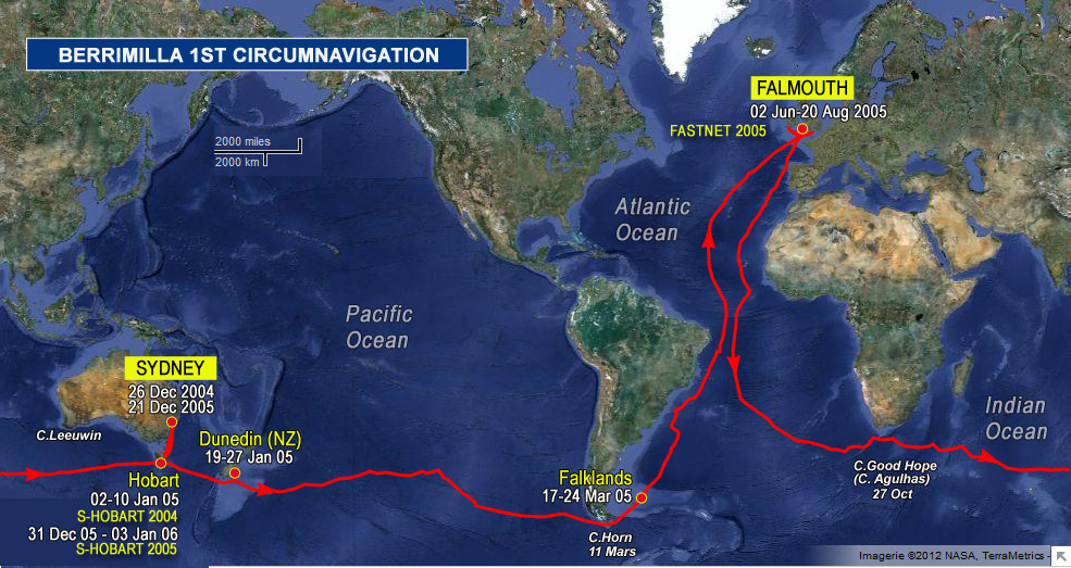
|
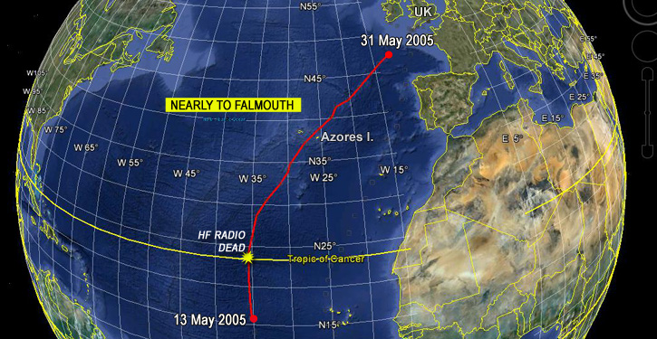
1-14. Nearly to Falmouth
Track
Logs ( 28 )
By Peter on May 13, 2005, at 0330 UTC
0330hrs 13 May 2005 UTC 17’03”N 035’22”W Map Ref 214 4903nm (2464nm to Falmouth)
Greetings fromTradewindTerritory(North variety),
I’ve spent the last couple of days trying to avoid sitting on my pelvic bones. The gunwale bumLesions, looking like pimples on the bum, caused by pressure, chafing, heat, damp etc; sometimes known as spotty botty, skipper’s seat or barnacle butt. . Unbelievably painful and irritating. is back again. I can sit sort of sidesaddle with all the weight on the bottom of the thigh on the cockpit seats or even better sit on top of the bottom washboard in the companionway. This last one is the most comfortable and gives the best relief to the constant jerky twisting motion that you get while sailing to windward in these lumpy short steep Tradewind seas. Many years ago I crossed the Atlantic and Pacific sailing downwind with the tradesBands of NW and SW winds either side of the equator that blow with more or less constant speed and direction all year. behind us beautiful,no sore bums in these conditions. Many times I would have looked back at the seas and thought….bloody hell I’d hate to be going into that….here we are doing just that.
Were about level with the Cape Verde Islands at the moment and a big slide to the left would send us downwind straight towards Antigua, I can seethe boat now parked stern to the quay in English Harbour, I can hear a steel band playing under the trees outside the Admiral’s Inn …..Ahhhhhh …downwind no sore bottom. But enough of this these are mutinous thoughts…..onwards..north …Falmouth for orders and all that nonsense.
Sitting on the washboard with the rear end inside the cabin and the rest of you in the cockpit facing aft it reminds me of the old westerns. At the end of a thirty day cattle drive there they are at the railhead stockyards sitting on the top rail of the cattle crush rolling a cigarette hanging their rear ends over the rail, saddlesore. It’s getting better now a little bit of harsh treatment to let it know who’s boss, a liberal application of metho to the raw bits seems to have sorted things out. It must be at least 30 days we have been going to windward.
Allan just read your latest soliloquy I’ll go out and contemplate the the night sky, consider us in silent companionship.
That’s enough of my misery you know I’m better I’m sitting down to write again….cheers Pete.
By Alex on May 13, 2005, at 0935 UTC
Topic(s): Ghosts, Stars
0935hrs 13 May 2005 UTC 17’29”N 035’24”W Map Ref 215 4929nm (2442nm to Falmouth)
A bit over an hour ago, (now much more at send time…) we crossed 1640N. Why is this worth mentioning? – just another number except that it is exactly 1000 miles north of the equator. I think there may be something special with breakfast tomorrow. It has taken us a bit over 9 days and there are 2500 miles to go, so approximately 23 days?? I think my ETAEstimated Time of Arrival was June 4 – still a bit optimistic, I think, but the numbers stack.
Berrimilla’s Mighty Media Machine has swung into action in the UK – actually a couple of friends have got on to assorted newspapers and TV stations and we are Being Contacted and Stories will be Written.
Bill, as a sponsorship musing follow up, the big media opportunity actually happens when we get back to Sydney, especially if we make the Sydney-HobartSydney-Hobart Race: often described as the most gruelling ocean race in the world, this annual race starts on 26th December from Sydney Harbour and ends in Hobart. The course is 628 nautical miles. start line. We could carry all sorts of logos entering harbour and racing. If we actually do make it, we will probably enter Oz in Eden on the way past going north, so there would be an opportunity to decorate.
Like the S2HSydney-Hobart Race: often described as the most gruelling ocean race in the world, this annual race starts on 26th December from Sydney Harbour and ends in Hobart. The course is 628 nautical miles., the FastnetFastnet Race: 608 mile biennial race from Cowes, UK, Isle of Wight, to the Fastnet Rock off Southern Ireland, finishing in Plymouth. Berrimilla took part in 2005 and 2009. can be divided into distinct stages. I don’t know enough about the course to do it for you, but from here, it looks as if getting out of the SolentStrait separating the Isle of Wight from the mainland of England., then around Portland Bill, Lands EndIt is the most westerly point of mainland Cornwall and England, about eight miles (13 km) west-southwest of Penzance., the Rock, Lands EndIt is the most westerly point of mainland Cornwall and England, about eight miles (13 km) west-southwest of Penzance., Plymouth would go close. Big tidal gate at Portland and at other headlands to the west. Because we will be one of the slowest boats out there, there may well be smaller subdivisions for us, especially west of Portland in the Channel tides. Will have to do some serious reading when we get to Falmouth, and talking to the experts. And I haven’t seen the sailing instructions so don’t know what restrictions on automatic steering gear there may be for the 2 handed division, but there wont be much time for sleeping.
Three hours is a long time. Sitting in the cockpit surrounded by twinkling phosphorescence below and the glowing depths of the Bowl of Night, there is opportunity for lots of idle musing. Like what to write in the next of these – how, when it is almost impossible to distinguish one day from another at the moment, do I find something interesting to waffle on about? I was looking at the Pole Star a few minutes ago and thinking that humans must have been using stars to establish direction for longer that we have developed and used our other basic skills. And then – on an earlier theme – thinking about the Ghosts I sail with out here – the hundreds of early Portugese, Spanish and then English sailors and perhaps the Danes and even the Phoenicians long before them, who began to sail the North Atlantic and to use the Pole Star to find their way home. Some famous – Magellan, Drake, da Gama, but most lost to history yet still very much out here. It’s easy to imagine them on the same open ocean in their primitive and tiny ships – probably apprehensive, often terrified, excited by discovery, united by their circumstances yet often divided by their difference in perspective about a particular voyage. Hence mutiny, and all sorts of cruelty and some brilliant achievements.
By Alex on May 13, 2005, at 1500 UTC
Topic(s): Ghosts, Liferaft, Meals
1500hrs 13 May 2005 UTC 18’00”N 035’21”W Map Ref 216 4960nm (2414nm to Falmouth)
Breakfast – Friday 13 May – the usual cardboard muesli activated by our composted dried fruit but this time washed down – no, washed has too much attitude – stroked down perhaps? by a snort of The GlenfiddichMalt whisky: a well known Scots Consultant. Too dreadful for words and, indeed, they fail me. So it seemed appropriate to break into my tiny stash of squashed Mars bars and nibble on the flat toffee-sticky end of one saved from some trauma a few weeks ago. We only have about 10 mars bars altogether – far too expensive in the Falklands, and they all got squashed around the time the liferaft departed. Pete is off chocolate – good lad, so the remains belong me.
I wonder if anyone found and reported the liferaft. Probably somewhere in or off southern Brazil. It is identifiable, so AMSAAustralian Maritime Safety Authority might know.
It’s been an alcoholic day – today is also the 50th day out of Stanley, so we allowed ourselves an extra ConsultationA regular engagement with alcohol. One might say this whole epic is a Consultation with a bit of a sail round it. See also Conservation Mode; Linear and Parallel Methods of Consultation and we may just need another to appease whoever is in charge of Fridays with a 13.
Malcom – what would be the notation for infinite improbability? infinity to the power infinity to the minus one? Thanks for Milky Way stuff (Mal – could you post pse? Ta)- I was a bit off with my diameter. Hope my ETAEstimated Time of Arrival is a bit closer.
KevinFleming, Kevin: manufacturer of stainless steel self steering device, aka KevvoStainless steel self steering device, built by Kevin Fleming, used on Berrimilla and countless others, used on Berrimilla and countless others; (Kevin Fleming, you're an absolute bloody gem! ) F – could you please get the spares on the road to my sister if they aren’t already. We’ll be needing them in less than a month. Thanks.
Back to the Pole Star and Ghosts – it’s surprising how, in an otherwise empty – vastly stretchily empty – space, all our forerunners have a real presence, yet who, standing at the corner of Times Square would even think of Columbus or Vespucci or Eric the Red, Cortez or even CookBritish explorer, navigator, cartographer, and captain in the Royal Navy. He made 3 voyages to the Pacific Ocean, during which he achieved the first recorded European contact with the eastern coastline of Australia and the Hawaiian Islands, and the first recorded circumnavigation of New Zealand. More on wikipedia. and Vancouver. Or the Mayflower. And I wonder if there is any tiny space in the Atlantic that Berrimilla could claim to be the first and only boat to cross? Probably less likely than on the other side of the Wall in the Pacific. The whalers in particular would have been everywhere, both sides.
By Malcom on May 13, 2005, at 2100 UTC
Topic(s): Astronomy, Stars
The Milky way is just 100,000 light year wide (diameter). Our sun is 26,000 light years from the center. The bulge of the disk at the center protudes 12,000 light years either side. The Milky way contains at least 250 billion stars, perhaps over 1 trillion.
By contrast the galaxy Andromeda (similar size of Milky Way) is 2.2 million light years away but it is on a collicion course closing at 8,000 km per hour. Hence a collision between the galaxies will be in about 3 billion years which as far as I can gather given the curent dawdle will be just after you are likely to arrive at Falmouth (I’ve estimated 6 June 3,000,002,005).
Polaris, Pleaides and Orion are certainly part of the Milky Way and deduce that all constellations, close etc. nebulae are.that what we see beyond our galaxies are other galaxies with bugger all in between except gas, dust, dark matter, energy and gravitational fileds
We have a gigantic black hole at the center of the galaxy so don’t sail too close to the edge of the Earth.
By Alex on May 14, 2005, at 0900 UTC
0900hrs 14 May 2005 UTC 19’42”N 035’25”W Map Ref 217 5062nm (2328nm to Falmouth)
This one’s a catch up on correspondence – I’m losing the plot a bit what with no sustained time on night watches to write these and all the ConsultationsA regular engagement with alcohol. One might say this whole epic is a Consultation with a bit of a sail round it. See also Conservation Mode; Linear and Parallel Methods of Consultation required as we keep passing milestones – or should that be watermarks?. Yesterday we had 50 days, 1000 miles, Friday 13 and the normal morning and evening sessions with one GP or another, and today, if we get lucky, there will be another at 20N – now only 18 miles away. As I write, some of our families and long time Berri mates are having dinner together and we are hoping to hear the satphone beepA short story by James Blish at us so that we can talk to them all.
Rowley – thanks for all that Global Challenge stuff- we’ve been watching our stern, but I think we were just about on their track at the equator and we are now way to the north. They will slow down a bit when they get to the equator! The NE tradesBands of NW and SW winds either side of the equator that blow with more or less constant speed and direction all year. have been more NNE for us but they may get lucky. That will be Pindar’s best chance of catching up a bit.
We are using an AutohelmAn electric device that uses the boat’s instruments and direct commands to steer the boat. It can steer a compass course or follow the wind. Both require constant vigilance by the crew. ST 4000 autopilot when KevvoStainless steel self steering device, built by Kevin Fleming, used on Berrimilla and countless others is having a rest, mostly following the windvaneStainless steel self steering device, built by Kevin Fleming, used on Berrimilla and countless others rather than the compass, so working just like KevvoStainless steel self steering device, built by Kevin Fleming, used on Berrimilla and countless others (the FlemingFleming, KevinFleming, Kevin: manufacturer of stainless steel self steering device, aka KevvoStainless steel self steering device, built by Kevin Fleming, used on Berrimilla and countless others, used on Berrimilla and countless others; (Kevin Fleming, you're an absolute bloody gem! ): manufacturer of stainless steel self steering device, aka KevvoStainless steel self steering device, built by Kevin Fleming, used on Berrimilla and countless others, used on Berrimilla and countless others; (KevinFleming, Kevin: manufacturer of stainless steel self steering device, aka KevvoStainless steel self steering device, built by Kevin Fleming, used on Berrimilla and countless others, used on Berrimilla and countless others; (Kevin Fleming, you're an absolute bloody gem! ) Fleming, you're an absolute bloody gem! )). As for Isobars, sorry, can’t help – can’t see the map. GRIBWeather files.
Graphics in Binary file: GRIB files associate a specific weather datum (eg wind velocity or atmospheric pressure) with a geographic position. Because the resulting file is a collection of these points they are extremely small and so ideal over slow links such as sailmail. stands for Graphics in Binary and it is a very sexy way of downloading weather information from NOAA computer models, I think in the USA. If you want to see it in action, you need sailmailSailmail is the system that Berrimilla uses for email communication. It is a non-profit association of yacht owners operating a network of private coast stations in the maritime Mobile Radio Service. or similar package or get onto pentacomstat website and find reference to Marc and sailmailSailmail is the system that Berrimilla uses for email communication. It is a non-profit association of yacht owners operating a network of private coast stations in the maritime Mobile Radio Service. and follow. Go and see Marc, if he’ll let you, and he’ll show you the setup we have on Berri. GribWeather files.
Graphics in Binary file: GRIB files associate a specific weather datum (eg wind velocity or atmospheric pressure) with a geographic position. Because the resulting file is a collection of these points they are extremely small and so ideal over slow links such as sailmail. takes some getting used to especially the scale versus your speed and has no localised predictions, hence our surprise down the S. American coast a few weeks ago.
Fiona, thanks for the Galaxy song – it’s been in the back of my mind for ages sort of subconsciously.
[ed: I like it too so it’s here]
KevinFleming, Kevin: manufacturer of stainless steel self steering device, aka KevvoStainless steel self steering device, built by Kevin Fleming, used on Berrimilla and countless others, used on Berrimilla and countless others; (Kevin Fleming, you're an absolute bloody gem! ) FlemingFleming, KevinFleming, Kevin: manufacturer of stainless steel self steering device, aka KevvoStainless steel self steering device, built by Kevin Fleming, used on Berrimilla and countless others, used on Berrimilla and countless others; (Kevin Fleming, you're an absolute bloody gem! ): manufacturer of stainless steel self steering device, aka KevvoStainless steel self steering device, built by Kevin Fleming, used on Berrimilla and countless others, used on Berrimilla and countless others; (KevinFleming, Kevin: manufacturer of stainless steel self steering device, aka KevvoStainless steel self steering device, built by Kevin Fleming, used on Berrimilla and countless others, used on Berrimilla and countless others; (Kevin Fleming, you're an absolute bloody gem! ) Fleming, you're an absolute bloody gem! ), you’re an absolute bloody gem! Thanks so much for organising spares and especially $ – I don’t know anyone else who would have done that! KevvoStainless steel self steering device, built by Kevin Fleming, used on Berrimilla and countless others, the unit, is still working fine – when it gets really rolly, like now, we give it a rest and use the autohelmAn electric device that uses the boat’s instruments and direct commands to steer the boat. It can steer a compass course or follow the wind. Both require constant vigilance by the crew. as long as the sun is out warming the solar panel because it is just a bit easier to fine tune as we go. But it has saved our bacon so many times now we will have to frame it or something when it eventually gets us home. Did you use the photo for your advert? You have my permission to quote from the website too if you want to, just acknowledge copyright and permission.
By Alex on May 14, 2005, at 1600 UTC
Topic(s): Birds
1600hrs 14 May 2005 UTC 20’18”N 035’27”W Map Ref 218 5098nm (2298nm to Falmouth)
Would you believe that two experienced old farts can’t tell the difference between The GlenfiddichMalt whisky: a well known Scots Consultant and Lambs Navy Rum?? We have two brown plastic bottles with decanted libations of each but the labels have disintegrated. So the smell test – I actually got it right that time, but when we then looked at and tasted our 20N Consultative Offering, we both thought we had got it wrong. It was only after serious investigation that we concluded we had the correct bottle. I bet very few people in a properly conducted blind test can really tell the difference between Dr Plonk and Mr Screech the Barber Surgeon anyway, so why should we worry. Just Consult to make sure.
So, yes, we crossed 20N and are now 70% of the way from Port Stanley – or 31 degrees to go. About 25k in the Falklands marathon – just downhill but with almost all the rest uphill till the last 5 k. Grind it out – we have lots of work to do.
The Chart puts us over the Cape Verde Basin – haven’t got depth contours on the laptop digital but probably just east of the Mid Atlantic Ridge. We are sailing through clumps of seaweed – small, about half a metre in diameter, like tangled spiky string, yellowish brown with perhaps a tinge of green. Lots of it, and there seems to be a different smell in the air, but that may just be the boot feralsInteresting biological colonies that grow and fester in seaboots. There are left foot ferals and right foot ferals and occasionally they get to cross breed and create fierce hybrids.Interesting biological colonies that grow and fester in seaboots. There are left foot feralsInteresting biological colonies that grow and fester in seaboots. There are left foot ferals and right foot ferals and occasionally they get to cross breed and create fierce hybrids. and right foot feralsInteresting biological colonies that grow and fester in seaboots. There are left foot ferals and right foot ferals and occasionally they get to cross breed and create fierce hybrids. and occasionally they get to cross breed and create fierce hybrids. having a clandestine outing. I remember reading about boats marooned in the Sargasso Sea surrounded by weed and windless but this is in the middle of the tradesBands of NW and SW winds either side of the equator that blow with more or less constant speed and direction all year.. Anyone know about it?
Wildlife – the hawklike bird finally deserted us close to St Peter & Paul rocks after perhaps three weeks of sporadic visits – perhaps it just goes up and down the coast following boats. Yesterday we saw a lovely white bird about half a metre span – very finely boned, almost transparent, sun shining through its wing feathers, the whole bird sharply carved and beautifully curved with two very long white tail feathers trailing behind but even those streamlined. It dived on a flying fish which it caught, swallowed, did a curiosity pass over us and was gone. Today two similar birds but black and without the long tail feathers, flying around in the wave troughs. Also did not stay long.
We seem to be approaching the northern edge of the TradesBands of NW and SW winds either side of the equator that blow with more or less constant speed and direction all year. – some higher clouds over the last two days and the wind lifting us occasionally to point directly at the Azores. NoiceAlexism for quite a lot of things which taste good or are going especially well! And two days of 6+ knots. NoicerAlexism for quite a lot of things which taste good or are going especially well!
Have you had a look at the Falmouth webcam? Will it be worth ringing home when we get close – doubt if we will manage the purple kiteSailors’ slang for a spinnaker but you never know. That would be really cool and classy.
By Alex on May 15, 2005, at 1030 UTC
Topic(s): Conspiracy Theory, Stars
1030hrs 15 May 2005 UTC 22’10”N 035’29”W Map Ref 219 5210nm (2204nm to Falmouth)
PropagationIn the logs, this refers to the radiation of signal energy and is customarily qualified by the words abysmal, ratshit or lousy dreadful this morning (15/1030Z) – you may not get this till tomorrow Z – started yesterday evening local.
Last night:
The Great big Bear is up in the top spreaders and – all going well – should be up over the masthead in a couple of nights. So the flea has humped its bluey all the way round the curve of the pachydermatous rump and is approaching the nice sunny bit half way up the topside. Pole Star at about our latitude (now 21N) above the horizon to the north. 25 knots, ENE, #2 and 2 reefs snugged down a bit for the night as the clouds looked rather dark and windy earlier. Now receding. I think the Cross has all but disappeared below the southern horizon – a bit cloudy down there so don’t know for certain.
Hardly dare write about this in case the ExaminerShe who asks awkward questions of the crew and tests them with difficult tasks. notices, but we’ve been hooningAs far as I can gather, if Berri were a horse, she’d have the bit between her teeth to be hooning it a bit over the last couple of days probably averaging a least 6kts. Unheard of. We expect it to go soft in a day or so and then back around to the south east to give us a bit of a lift. All the parts are crossed.
Later – now early this morning local and breakfast time – sort of – hard if you’re on 3X3:
And these two grizzled old farts from central casting at Fox still don’t really know whether they are drinking rum or single malt. They think the colour is the real give-away and it’s Lambs Navy but not absolutely sure. Never make real sailors out of these two. Lash ‘em to the bus shelterExplanation here and have pigeons poo on them – and dogs sniff a lot and lift their legs. The Ancestors are probably Aghast. Apoplectic. Agonised. Anguished. Abject. Ashamed. Astounded. Try it some time – get someone to wake you in the middle of the night in very dim light with a nip of something and see how good you are. Might be a bit easier if you have had lots of recent practice – which we haven’t but might need to commence.
Later still:
15/1200Z – first time ever – can’t connect to any sailmailSailmail is the system that Berrimilla uses for email communication. It is a non-profit association of yacht owners operating a network of private coast stations in the maritime Mobile Radio Service. station anywhere, so this update will just get expanded and the two messages I know are waiting for us will have to wait for at least another 6 hours. Poo.
Pete saw a ship last night, heading north west – perhaps Cape Verdes to NY – too far north now to see the Global Challenge boats which will have come up the east side of the S. Atlantic just west of the Benguela current, to cross the equator a long way further east than we did and will now be heading south of us towards Boston. I think.
And yet more later:
We are now in what looks like the beginning of the Azores high, although we are still 1000+ miles south of the archipelago. Overcast, cloud base getting lower, looking very frontal but quite soft. Pity we aren’t 300 miles further north, where the wind should be turning southerly and later SW going towards Falmouth. But can’t sneeze at tracking north at 6.5 knots.
Anne G – if you are still out there – I’ve lost the reference to the St Malo Cap Horniers mob – buried in the past logs, sorry – would you be kind enough to contact them and ask them if they’d like to hear from us (and, perhaps, if you think they don’t take themselves too seriously, ask how we get our free DIY earring and p.i.t.w. kits)?. Seems like something worth investigating at least. Perhaps, on second thoughts, ear piercing out here is a pleasure we may not need.
This will be too big to send if I go wittering on so here endeth this idle nonsense.
By Peter on May 15, 2005, at 1530 UTC
1530hrs 15 May 2005 UTC 22’36”N 035’25”W Map Ref 220 5237nm (2180nm to Falmouth)
Here’s a project for someone with time to spare. In the days of square riggers trying to minimise their costs, the shipping companies, especially the Germans, compiled statistical charts showing the data from the logs of thousands of voyages out from Europe via the Horn and the Cape of Good Hope to Australia, San Francisco, Hong Kong and just about everywhere else (and back as well). The charts had lines on them called isochronesJoining points on a chart that were the same number of days out from, say, London en route to Cape Horn using different tracks. – joining points that were the same number of days out from, say, London en route to Cape Horn using different tracks. These lines bulged outwards along the tracks that gave the fastest passages at different times of the year, so the Germans, in particular the Laeisz Line (also known as the Flying P line because all their ships’ names began with a P – Preussen, Potosi, Parma, Pamir…), were able to direct all their ships to cross the equator going south at between 27 and 28 degrees west. As a result, their ships were able to make three voyages to Australia each year against everyone else’s two.
I want the isochrone charts from August to December for our return trip leaving Falmouth for Sydney in late August via the Cape of Good Hope. A signed ‘Berrimilla Around’ shirt for the first person who gives me a viable reference that I can use when we get to Falmouth. This almost certainly means that they must be accessible via the internet in some way. I tried to find them before we left Sydney but ran out of time. Might help if you speak German. The word has another more modern usage, for things occurring at the same time, and Google finds all these but none of the others.
These days similar information almost certainly lives in lots of computer databases – Whitbread races, Volvo and Vendee races, Dame E. ad all the others – but is now proprietary and anyway I think there’s something a bit special about using the older charts to plan the route.
By Malcom on May 16, 2005, at 0630 UTC
Topic(s): Communications
0630hrs 16 May 2005 UTC 24’00”N 035’27”W Map Ref 221 5321nm (2111nm to Falmouth)
[ed: The HFHigh Frequency – usually refers to HF radio which is long range digital radio that Berrimilla used to send all but a few of the logs on both circumnavigations. The radio was connected via a Pactor 3 digital modem to Alex’s laptop and used the Sailmail software application called Airmail to send emails and pull in emails, weather and GRIB files. Airmail also supports Iridium satellite telephone messaging and Alex used this as backup when the HF radio died approaching England. radio (main form of communication) is currently inoperable so log updates will be via SatcomC. Unfortunately, at one cent per character, they will probably be much shorter until the problem is resolved. For example, this log entry would have cost $8.10!
Mail to Berri will suffer similar limitations. Please don’t stop sending messages but, if you can keep them very short, that would make my life easier! Short ones (about 200 characters) will go as is, long ones will probably be summarised and sent in full as soon as possible. Any critical messages will, of course, receive priority – and, by ‘critical’ I mean ‘important’ rather than ‘disparaging’ 
Those of you who have Berri’s SailMail address, please note that I will monitor it and forward any messages via SatcomC using the above rules.]
By Malcom on May 16, 2005, at 1030 UTC
1030hrs 16 May 2005 UTC
[ed: Phone call from Alex – HF radio is dead and tonight’s SatcomC email to them crashed the PC. Therefore only very short, urgent messages can be sent at this stage. They will do very short Sitreps to keep us abreast of progress.]
By Alex on May 16, 2005, at 1045 UTC
1045hrs 16 May 2005 UTC 24’25”N 035’25”W Map Ref 222 5346nm (2090nm to Falmouth)
catastrophe. will try to give all y’all short updates daily but must nurse system. also v. expensive to use satcom. examinerShe who asks awkward questions of the crew and tests them with difficult tasks. back with a vengeance – nasty low to nw and central casting heroes in the poo again.
By Alex on May 16, 2005, at 1515 UTC
Topic(s): Communications, Computer crashes
1515hrs 16 May 2005 UTC 24’52”N 035’17”W Map Ref 223 5374nm (2063nm to Falmouth)
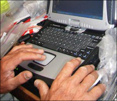
desperately frustrating day trying 2 find prob. with hfHigh Frequency – usually refers to HF radio which is long range digital radio that Berrimilla used to send all but a few of the logs on both circumnavigations. The radio was connected via a Pactor 3 digital modem to Alex’s laptop and used the Sailmail software application called Airmail to send emails and pull in emails, weather and GRIB files. Airmail also supports Iridium satellite telephone messaging and Alex used this as backup when the HF radio died approaching England. – huge un/repack of both sides of back of boat – clearly lots of moisture has got under q’berths – 30 amp fuse ok, has power. no luck. cant find spare fuses – thought they were taped to fuseholders but not, nor with elec. spares. physically v tiring. laptop crashing every time i managed to get sobSoftware on Board, from Digitboat – navigation software used by Alex for both circumnavigations. and satcom to work together ) reboot each time. seems to be intermittent incompat’y – have sorted timeclock difference – may be when satcom receives or transmits. depressing – marvinThe manically depressed robot with a “brain the size of a planet” from HHGTTGThe Hitch Hiker’s Guide to the Galaxy by Douglas Adams; essential reading for those trying to understand these logs. You may be none the wiser once you’ve read it, but at least you’ll have tried. More here without emotion – not this old fart.
advised to stay high because nasty low forming to west. wind/sea just 2 much for #2 + 2 reefs ) down to #3 tracking about 010t @ 5+ knots – down from 6+ with 3 but safer and easier on boat and rig. and crew. crossed trop of cancer too – consltd. it’s lambs navy, but by colour alone. amazing.
jeremy b in falmth – appreciate if u cd finger best avail. marine electrician for us asap after arrival – probably minimum 2 day job.
By Alex on May 16, 2005, at 2230 UTC
2230hrs 16 May 2005 UTC 25’29”N 035’07”W Map Ref 224 5412nm (2028nm to Falmouth)
full o’cast – high, hazy thin cloud, some lower cu and pale half moon glowing thro directly o’head. #3 and full main – really needs #2 – and mkng – 5 kts )) azores. getting met area 2 egc wxShort for ‘weather’ from satcomc so not completely blind. tomoz, will unpack nav qberth again and try to get to 5 amp fuse in radio. cant think what else could be.
satcom seems to be working after frust’ing times earlier. if i had any hair… mal sending ferociously summarised mailcalls to keep cost down. boot feralsInteresting biological colonies that grow and fester in seaboots. There are left foot ferals and right foot ferals and occasionally they get to cross breed and create fierce hybrids.Interesting biological colonies that grow and fester in seaboots. There are left foot feralsInteresting biological colonies that grow and fester in seaboots. There are left foot ferals and right foot ferals and occasionally they get to cross breed and create fierce hybrids. and right foot feralsInteresting biological colonies that grow and fester in seaboots. There are left foot ferals and right foot ferals and occasionally they get to cross breed and create fierce hybrids. and occasionally they get to cross breed and create fierce hybrids. laughing again as weather cools – water temp now 23.
almost abeam canaries – uk, spain, gib, nw africa + newfndld all on nav screen. exciting.
By Alex on May 17, 2005, at 0400 UTC
0400hrs 17 May 2005 UTC 25’58”N 035’00”W Map Ref 225 5441nm (2001nm to Falmouth)
wind up to 30 – 2 reefs, trkg – 015t – falmouth 035. vmgVelocity made good – loosely, speed in the right direction. – 5.
still applying metho to tender nethers. oz metho is clear like gin (would that it were…) but stuff bought in f.i. @ gbsmkg price of – 3 pnds/ltr has purple dye added which also smells foul. when applied to tender parts, paints them purple. lucky, perhaps, no resident baboon population else in hi demand.
By Alex on May 18, 2005, at 0003 UTC
Topic(s): Communications 0003hrs 18 May 2005 UTC 27’48”N 034’31”W Map Ref 226 5554nm (1897nm to Falmouth)
[ed: Alex’s description of current problems] all systems off for 2 hrs this am investigating hfHigh Frequency – usually refers to HF radio which is long range digital radio that Berrimilla used to send all but a few of the logs on both circumnavigations. The radio was connected via a Pactor 3 digital modem to Alex’s laptop and used the Sailmail software application called Airmail to send emails and pull in emails, weather and GRIB files. Airmail also supports Iridium satellite telephone messaging and Alex used this as backup when the HF radio died approaching England. big double un/repack again. followed marty’s instructions except ?no circuit breaker?if so where – 802 direct connect 2 battery?? no joy but found negative bus badly corroded and fixed. even dismounted m802 box f’m bulkhd (try it sometime with boat corkscrewing 10 ft.) removed cover and inner cover 2 check 5 amp fuse (and no spare fuse attached as instructions say there is). 20 tiny screws fiendishly diff 2 access and esp replace but managed sans dropping one.
amzg. all reassembled and still no power. spbf very difficult enterprise and no real result ) had double consultationA regular engagement with alcohol. One might say this whole epic is a Consultation with a bit of a sail round it. See also Conservation Mode; Linear and Parallel Methods of Consultation with the doctorGuinness to recognise heroic failure. cd be combo of equipt. failure and dud power switch else stumped. failure seemed catastrophic – no warning, total instant loss of power while transmitting.. wil have 2 wait til fmth.
so have decided hang expense and will continu (shorter) udates via satcom – this one about s15+ to send – pse buy lots of shirts, everyone – fenwickA friend and clearly a colourful character and isabellaAlex's sister organising and should be arvailable soon – we’ll need some support by the time we get to the start line in sydney. malcolm will send your emails to us as system allows and may have to sumarise to reduce cost. don’t stop sending – we need youse and only a few days to go and all y’all can have a drink with us.
aiming for middle of azores – 30 kts from e and lifting us a bit. 766 to az so 6 days approx then 10 to fmth agw. egc says nasty low forming to west – bloody promethea again – will really enjoy consulting with her when we eventually get there. hard examiners are best. now at 25k in marathon. headbang just beginning. baboon bott glowing. nearly time to meet boot feralsInteresting biological colonies that grow and fester in seaboots. There are left foot ferals and right foot ferals and occasionally they get to cross breed and create fierce hybrids.Interesting biological colonies that grow and fester in seaboots. There are left foot feralsInteresting biological colonies that grow and fester in seaboots. There are left foot ferals and right foot ferals and occasionally they get to cross breed and create fierce hybrids. and right foot feralsInteresting biological colonies that grow and fester in seaboots. There are left foot ferals and right foot ferals and occasionally they get to cross breed and create fierce hybrids. and occasionally they get to cross breed and create fierce hybrids. again – noticeably cooler at night and dry feet a good idea.
By Alex on May 18, 2005, at 0430 UTC
0430hrs 18 May 2005 UTC 28’15”N 034’28”W Map Ref 227 5582nm (1874nm to Falmouth)
v mt ocean. no birds, fish, people – 1st ship for days just past astern lisbn braz?. still lots seaweed. + ghosts. doing 130 nm days ) w end of az’s. xpct collect front to n with w change to carry us home – swiiing looow…no fun being out of contact – hugely enjoy interact’n w. y’all. anticp’n growing + dstnce seems growing parallel – long way 2 go, v chancy wxShort for ‘weather’ sit’n.. last few days for etaEstimated Time of Arrival’s rnvp @ 35n say 3 days. bferals thriving – other wldlfe in grotty clothes bags – all salt encrstd.
3-6 nightwtch longest – moon down, shwrs, drk. gbear o’head polestar ahead – all hpng xcpt hfHigh Frequency – usually refers to HF radio which is long range digital radio that Berrimilla used to send all but a few of the logs on both circumnavigations. The radio was connected via a Pactor 3 digital modem to Alex’s laptop and used the Sailmail software application called Airmail to send emails and pull in emails, weather and GRIB files. Airmail also supports Iridium satellite telephone messaging and Alex used this as backup when the HF radio died approaching England. radio. cool 2 b here not s ocean.
tks ak 4 contacts. tks f’wick for lots. old glowbum here v grateful.
not confdnt in satcom some msgs not delvrd so kpng short.
luv youse all
By Alex on May 18, 2005, at 1050 UTC
1050hrs 18 May 2005 UTC 28’50”N 034’23”W Map Ref 228 5617nm (1843nm to Falmouth)
gale force winds (34 – 47kts) forecast for our area next week – surprising how little concern that evokes – already in 30 – only real worry is for rig, nowt to report – just grinding it out – patience etc and titan ur(purple)anus. photo of tu ship might go well on back of t shirt – is? fenwickA friend and clearly a colourful character? all y’all? will try to do chatty one later.
By Alex on May 18, 2005, at 1330 UTC
1330hrs 18 May 2005 UTC 29’06”N 034’17”W Map Ref 229 5634nm (1827nm to Falmouth)
daily watch rutine 4 blubums midnt-3,pete:3-6alex these two are long and lonely unless moon is up, phosph, dolphins etc.6-9 p -sets up solar panl, checks for damage, chafe etc 9-12 a -no hfHigh Frequency – usually refers to HF radio which is long range digital radio that Berrimilla used to send all but a few of the logs on both circumnavigations. The radio was connected via a Pactor 3 digital modem to Alex’s laptop and used the Sailmail software application called Airmail to send emails and pull in emails, weather and GRIB files. Airmail also supports Iridium satellite telephone messaging and Alex used this as backup when the HF radio died approaching England. so little to do – checks nav, satcom etc. try to read, write emails, not easy when on watch.
1200 hi point – consultationA regular engagement with alcohol. One might say this whole epic is a Consultation with a bit of a sail round it. See also Conservation Mode; Linear and Parallel Methods of Consultation – half can of conslttve lubricnt each – only the dr and 2 smoothies left. 12-3 p, 3-6 a diff 2 sleep in these – hot, windy, humid big motion. general maintenance jobs when poss.
6-9 p – cooks dinner, evening consltn – if an ‘on’day, g+t woohooa primitive, exultant, gibbon-like call given out by an old geezerDictionaries define a geezer as an old person, generally an eccentric old man. Its origin likely in the word masquerader (colloquially, guiser) from Middle English gysar. Go figure, as the Americans say.; many variations as listed, in order of emphasis:
Woohoo
Woooohoooa primitive, exultant, gibbon-like call given out by an old geezerDictionaries define a geezer as an old person, generally an eccentric old man. Its origin likely in the word masquerader (colloquially, guiser) from Middle English gysar. Go figure, as the Americans say.; many variations as listed, in order of emphasis:
Woohoo
Woooohooo
WOOOHOOOa primitive, exultant, gibbon-like call given out by an old geezerDictionaries define a geezer as an old person, generally an eccentric old man. Its origin likely in the word masquerader (colloquially, guiser) from Middle English gysar. Go figure, as the Americans say.; many variations as listed, in order of emphasis:
Woohoo
Woooohooo
WOOOHOOO
WOOOHOOO!
WOOOOOOOOHOOOOOOOOOa primitive, exultant, gibbon-like call given out by an old geezerDictionaries define a geezer as an old person, generally an eccentric old man. Its origin likely in the word masquerader (colloquially, guiser) from Middle English gysar. Go figure, as the Americans say.; many variations as listed, in order of emphasis:
Woohoo
Woooohooo
WOOOHOOO
WOOOHOOO!
WOOOOOOOOHOOOOOOOOO!!
WOOOHOOOa primitive, exultant, gibbon-like call given out by an old geezerDictionaries define a geezer as an old person, generally an eccentric old man. Its origin likely in the word masquerader (colloquially, guiser) from Middle English gysar. Go figure, as the Americans say.; many variations as listed, in order of emphasis:
Woohoo
Woooohooo
WOOOHOOO
WOOOHOOO!
WOOOOOOOOHOOOOOOOOOa primitive, exultant, gibbon-like call given out by an old geezerDictionaries define a geezer as an old person, generally an eccentric old man. Its origin likely in the word masquerader (colloquially, guiser) from Middle English gysar. Go figure, as the Americans say.; many variations as listed, in order of emphasis:
Woohoo
Woooohooo
WOOOHOOO
WOOOHOOO!
WOOOOOOOOHOOOOOOOOO!!!
WOOOOOOOOHOOOOOOOOOa primitive, exultant, gibbon-like call given out by an old geezerDictionaries define a geezer as an old person, generally an eccentric old man. Its origin likely in the word masquerader (colloquially, guiser) from Middle English gysar. Go figure, as the Americans say.; many variations as listed, in order of emphasis:
Woohoo
Woooohooo
WOOOHOOO
WOOOHOOO!
WOOOOOOOOHOOOOOOOOO!!
WOOOHOOOa primitive, exultant, gibbon-like call given out by an old geezerDictionaries define a geezer as an old person, generally an eccentric old man. Its origin likely in the word masquerader (colloquially, guiser) from Middle English gysar. Go figure, as the Americans say.; many variations as listed, in order of emphasis:
Woohoo
Woooohooo
WOOOHOOO
WOOOHOOO!
WOOOOOOOOHOOOOOOOOOa primitive, exultant, gibbon-like call given out by an old geezerDictionaries define a geezer as an old person, generally an eccentric old man. Its origin likely in the word masquerader (colloquially, guiser) from Middle English gysar. Go figure, as the Americans say.; many variations as listed, in order of emphasis:
Woohoo
Woooohooo
WOOOHOOO
WOOOHOOO!
WOOOOOOOOHOOOOOOOOO!!!
WOOOOOOOOHOOOOOOOOOa primitive, exultant, gibbon-like call given out by an old geezerDictionaries define a geezer as an old person, generally an eccentric old man. Its origin likely in the word masquerader (colloquially, guiser) from Middle English gysar. Go figure, as the Americans say.; many variations as listed, in order of emphasis:
Woohoo
Woooohooo
WOOOHOOO
WOOOHOOO!
WOOOOOOOOHOOOOOOOOO!! looked fwd to all day – else on ‘off days’ (on,off,off). glass of dr plonk. dr plonk with meal, wash up, a sleeps for last hour then 9-12a puts away panel, tidy up, watch stars and gbear climb. will prob run out of gin + dr p.
saw gb right way up yest 4 1st time pointing up to n star. woohooa primitive, exultant, gibbon-like call given out by an old geezerDictionaries define a geezer as an old person, generally an eccentric old man. Its origin likely in the word masquerader (colloquially, guiser) from Middle English gysar. Go figure, as the Americans say.; many variations as listed, in order of emphasis:
Woohoo
Woooohoooa primitive, exultant, gibbon-like call given out by an old geezerDictionaries define a geezer as an old person, generally an eccentric old man. Its origin likely in the word masquerader (colloquially, guiser) from Middle English gysar. Go figure, as the Americans say.; many variations as listed, in order of emphasis:
Woohoo
Woooohooo
WOOOHOOOa primitive, exultant, gibbon-like call given out by an old geezerDictionaries define a geezer as an old person, generally an eccentric old man. Its origin likely in the word masquerader (colloquially, guiser) from Middle English gysar. Go figure, as the Americans say.; many variations as listed, in order of emphasis:
Woohoo
Woooohooo
WOOOHOOO
WOOOHOOO!
WOOOOOOOOHOOOOOOOOOa primitive, exultant, gibbon-like call given out by an old geezerDictionaries define a geezer as an old person, generally an eccentric old man. Its origin likely in the word masquerader (colloquially, guiser) from Middle English gysar. Go figure, as the Americans say.; many variations as listed, in order of emphasis:
Woohoo
Woooohooo
WOOOHOOO
WOOOHOOO!
WOOOOOOOOHOOOOOOOOO!!
WOOOHOOOa primitive, exultant, gibbon-like call given out by an old geezerDictionaries define a geezer as an old person, generally an eccentric old man. Its origin likely in the word masquerader (colloquially, guiser) from Middle English gysar. Go figure, as the Americans say.; many variations as listed, in order of emphasis:
Woohoo
Woooohooo
WOOOHOOO
WOOOHOOO!
WOOOOOOOOHOOOOOOOOOa primitive, exultant, gibbon-like call given out by an old geezerDictionaries define a geezer as an old person, generally an eccentric old man. Its origin likely in the word masquerader (colloquially, guiser) from Middle English gysar. Go figure, as the Americans say.; many variations as listed, in order of emphasis:
Woohoo
Woooohooo
WOOOHOOO
WOOOHOOO!
WOOOOOOOOHOOOOOOOOO!!!
WOOOOOOOOHOOOOOOOOOa primitive, exultant, gibbon-like call given out by an old geezerDictionaries define a geezer as an old person, generally an eccentric old man. Its origin likely in the word masquerader (colloquially, guiser) from Middle English gysar. Go figure, as the Americans say.; many variations as listed, in order of emphasis:
Woohoo
Woooohooo
WOOOHOOO
WOOOHOOO!
WOOOOOOOOHOOOOOOOOO!!
WOOOHOOOa primitive, exultant, gibbon-like call given out by an old geezerDictionaries define a geezer as an old person, generally an eccentric old man. Its origin likely in the word masquerader (colloquially, guiser) from Middle English gysar. Go figure, as the Americans say.; many variations as listed, in order of emphasis:
Woohoo
Woooohooo
WOOOHOOO
WOOOHOOO!
WOOOOOOOOHOOOOOOOOOa primitive, exultant, gibbon-like call given out by an old geezerDictionaries define a geezer as an old person, generally an eccentric old man. Its origin likely in the word masquerader (colloquially, guiser) from Middle English gysar. Go figure, as the Americans say.; many variations as listed, in order of emphasis:
Woohoo
Woooohooo
WOOOHOOO
WOOOHOOO!
WOOOOOOOOHOOOOOOOOO!!
WOOOHOOOa primitive, exultant, gibbon-like call given out by an old geezerDictionaries define a geezer as an old person, generally an eccentric old man. Its origin likely in the word masquerader (colloquially, guiser) from Middle English gysar. Go figure, as the Americans say.; many variations as listed, in order of emphasis:
Woohoo
Woooohooo
WOOOHOOO
WOOOHOOO!
WOOOOOOOOHOOOOOOOOOa primitive, exultant, gibbon-like call given out by an old geezerDictionaries define a geezer as an old person, generally an eccentric old man. Its origin likely in the word masquerader (colloquially, guiser) from Middle English gysar. Go figure, as the Americans say.; many variations as listed, in order of emphasis:
Woohoo
Woooohooo
WOOOHOOO
WOOOHOOO!
WOOOOOOOOHOOOOOOOOO!!!
WOOOOOOOOHOOOOOOOOOa primitive, exultant, gibbon-like call given out by an old geezerDictionaries define a geezer as an old person, generally an eccentric old man. Its origin likely in the word masquerader (colloquially, guiser) from Middle English gysar. Go figure, as the Americans say.; many variations as listed, in order of emphasis:
Woohoo
Woooohooo
WOOOHOOO
WOOOHOOO!
WOOOOOOOOHOOOOOOOOO!!. cross now below horizon – mixed feelings. achievement, work still to do (panic but still have towel) absent friend etc.
54nm to 30n + next watermark.hi fm pete
p,p,p,+ tu bigtime.
By Alex on May 18, 2005, at 1700 UTC
1700hrs 18 May 2005 UTC 29’23”N 034’07”W Map Ref 230 5653nm (1809nm to Falmouth)
an hr ago got wind shift to se now pointing directly at falmth. with no lumps in between @ 6 kts. first time since boxing day. all y’all have to be here to know how good it feels – don’t tell
promethea cos she’ll move the pieces but temporary as it must be, its exhilarating. pete asleep – dont want to wake him but today is an ‘on’ day so g+t’s later. wooohoooa primitive, exultant, gibbon-like call given out by an old geezerDictionaries define a geezer as an old person, generally an eccentric old man. Its origin likely in the word masquerader (colloquially, guiser) from Middle English gysar. Go figure, as the Americans say.; many variations as listed, in order of emphasis:
Woohoo
Woooohooo
WOOOHOOO
WOOOHOOO!
WOOOOOOOOHOOOOOOOOOa primitive, exultant, gibbon-like call given out by an old geezerDictionaries define a geezer as an old person, generally an eccentric old man. Its origin likely in the word masquerader (colloquially, guiser) from Middle English gysar. Go figure, as the Americans say.; many variations as listed, in order of emphasis:
Woohoo
Woooohooo
WOOOHOOO
WOOOHOOO!
WOOOOOOOOHOOOOOOOOO!!..
gives etaEstimated Time of Arrival fmth 30 may. not possible but nice to comtemplate. enjoy your cornflakes.
By Alex on May 18, 2005, at 2200 UTC
2200hrs 18 May 2005 UTC 29’46”N 033’47”W Map Ref 231 5682nm (1780nm to Falmouth)
stll in se wind ) fmth.e of azores. g+t cons. exlnt. – best ever. suspect drama of entprse now gone 4 most of ay’a – we like it that way. but nail btng 4 us. sad re comms cos i do best with immediacy – not up to journal entries for latr. so will try to do these really short ones for duratn. now at approx latit of fenwickery but getting colder. sydney lat 240nm up the rd.
isab ta re sj + recce. david – button pressed – now in gt w’shp on magtha. cool – slartyMegrathean planet designer from HHGTTGThe Hitch Hiker’s Guide to the Galaxy by Douglas Adams; essential reading for those trying to understand these logs. You may be none the wiser once you’ve read it, but at least you’ll have tried. More here whose favourite job was doing “the wrinkly bits in fjords”; He carved his face on the big rock above Baie de L’Oiseau in the Kerguelens. moving fmth closer. gm h, tks, good 2 hear.
By Alex on May 19, 2005, at 1030 UTC
1030hrs 19 May 2005 UTC 30’40”N 033’00”W Map Ref 232 5749nm (1712nm to Falmouth)
anor turnerTurner, John Mallord William (1775 - 1851); one of the founders of English watercolour painting renowned for his studies of sea and sky in every weather night blk clds rushng across haze veiled moon. gbear + polaris now nearly on p. beam as we head towards the barn. where they shld b. still in se wnd. cooool.
just had crosng 30n constn 4 brkfst. noiice. and anor big unpack 2 trace anor elec prob – all due moisture we think no joy.
jeremyb in fmth tks. lk fwd 2 mtg u. yc swing mrng wd b good if can access pontoon daytime. tks
By Alex on May 19, 2005, at 2200 UTC
2200hrs 19 May 2005 UTC 31’31”N 032’09”W Map Ref 233 5816nm (1645nm to Falmouth)
really misng ay’a. seems dream run endng – in se crnr of hi mvg ne wind now dropng + easng so hi perhaps mvg away. sw front xpctd perhps w’lies after.
o’cst high haze ctn wooly moon high above. grind. grind.grind. constve lubricnt praps just adeqte. all 3 p shrouds now suspct despite shock crd to prvnt flop. shkles clamped 2 each + can attach braces. have 2 clmb mst tomoz chck top swages. what is it wth stnls stl? new rig shld not fail like this. cnsdring gal + thimbles for return trip – cant afford this nonsense. serious tlk with rigger in fmth.
By Alex on May 20, 2005, at 0900 UTC
0900hrs 20 May 2005 UTC
etaEstimated Time of Arrival comp ends @ 35n. sugst ay’a amend pred’ns to exact time we pass br’wtr fmth. june 4@ 1200 still my bet, may b pesmstc. just recd safet msg re derelct 8-10tmtr s/v 60 nm to n. not enough wind to go look. all v soft – hi just to n weakng hope for sw front soon – xpctd 23rd may b 2 far away 2 help..
jeanne pse send dym. address in fmth
ben tks 4 fedbak.
[ed: Based on Alex’s comment about the ETA competition, I’ve taken an executive decision and have opened up a second part of the competition. There will now also be a prize for the person who first guesses the closest time (irrespective of date) to the time they pass the breakwater at Falmouth. Times will be assumed to be UTC unless you specify otherwise. So send your guesses to falmoutheta@berrimilla.com.]
By Alex on May 20, 2005, at 1300 UTC
1300hrs 20 May 2005 UTC 32’31”N 031’13”W Map Ref 234 5893nm (1569nm to Falmouth)
stll hdg ) the barn 6kts. huge tnkr (?tu?.) just past ahead 3nm. no sign drfitng s/v (kahinka f. any 1 kno story?). fixd chrge problm – bypast regltr for turbne. xpct pass clse san mig is azores 3 days time. v big port m o ‘wr all around. some flotsm – fshng gear? able get euro + n.af radio stns – 1st sign approachng lndfl. no birds, bootferals feastng on new sox + cheesy bits. baboons baying frm gib. hope poor swimmrs else brits may hve 2 leave rock. awaitng promethea’s nxt move. mast climb pstpnd as wind up a bit – not rlly nec. precaut. only. today ‘on’ day. hoooley doooley woohooa primitive, exultant, gibbon-like call given out by an old geezerDictionaries define a geezer as an old person, generally an eccentric old man. Its origin likely in the word masquerader (colloquially, guiser) from Middle English gysar. Go figure, as the Americans say.; many variations as listed, in order of emphasis:
Woohoo
Woooohoooa primitive, exultant, gibbon-like call given out by an old geezerDictionaries define a geezer as an old person, generally an eccentric old man. Its origin likely in the word masquerader (colloquially, guiser) from Middle English gysar. Go figure, as the Americans say.; many variations as listed, in order of emphasis:
Woohoo
Woooohooo
WOOOHOOOa primitive, exultant, gibbon-like call given out by an old geezerDictionaries define a geezer as an old person, generally an eccentric old man. Its origin likely in the word masquerader (colloquially, guiser) from Middle English gysar. Go figure, as the Americans say.; many variations as listed, in order of emphasis:
Woohoo
Woooohooo
WOOOHOOO
WOOOHOOO!
WOOOOOOOOHOOOOOOOOOa primitive, exultant, gibbon-like call given out by an old geezerDictionaries define a geezer as an old person, generally an eccentric old man. Its origin likely in the word masquerader (colloquially, guiser) from Middle English gysar. Go figure, as the Americans say.; many variations as listed, in order of emphasis:
Woohoo
Woooohooo
WOOOHOOO
WOOOHOOO!
WOOOOOOOOHOOOOOOOOO!!
WOOOHOOOa primitive, exultant, gibbon-like call given out by an old geezerDictionaries define a geezer as an old person, generally an eccentric old man. Its origin likely in the word masquerader (colloquially, guiser) from Middle English gysar. Go figure, as the Americans say.; many variations as listed, in order of emphasis:
Woohoo
Woooohooo
WOOOHOOO
WOOOHOOO!
WOOOOOOOOHOOOOOOOOOa primitive, exultant, gibbon-like call given out by an old geezerDictionaries define a geezer as an old person, generally an eccentric old man. Its origin likely in the word masquerader (colloquially, guiser) from Middle English gysar. Go figure, as the Americans say.; many variations as listed, in order of emphasis:
Woohoo
Woooohooo
WOOOHOOO
WOOOHOOO!
WOOOOOOOOHOOOOOOOOO!!!
WOOOOOOOOHOOOOOOOOOa primitive, exultant, gibbon-like call given out by an old geezerDictionaries define a geezer as an old person, generally an eccentric old man. Its origin likely in the word masquerader (colloquially, guiser) from Middle English gysar. Go figure, as the Americans say.; many variations as listed, in order of emphasis:
Woohoo
Woooohooo
WOOOHOOO
WOOOHOOO!
WOOOOOOOOHOOOOOOOOO!!
WOOOHOOOa primitive, exultant, gibbon-like call given out by an old geezerDictionaries define a geezer as an old person, generally an eccentric old man. Its origin likely in the word masquerader (colloquially, guiser) from Middle English gysar. Go figure, as the Americans say.; many variations as listed, in order of emphasis:
Woohoo
Woooohooo
WOOOHOOO
WOOOHOOO!
WOOOOOOOOHOOOOOOOOOa primitive, exultant, gibbon-like call given out by an old geezerDictionaries define a geezer as an old person, generally an eccentric old man. Its origin likely in the word masquerader (colloquially, guiser) from Middle English gysar. Go figure, as the Americans say.; many variations as listed, in order of emphasis:
Woohoo
Woooohooo
WOOOHOOO
WOOOHOOO!
WOOOOOOOOHOOOOOOOOO!!
WOOOHOOOa primitive, exultant, gibbon-like call given out by an old geezerDictionaries define a geezer as an old person, generally an eccentric old man. Its origin likely in the word masquerader (colloquially, guiser) from Middle English gysar. Go figure, as the Americans say.; many variations as listed, in order of emphasis:
Woohoo
Woooohooo
WOOOHOOO
WOOOHOOO!
WOOOOOOOOHOOOOOOOOOa primitive, exultant, gibbon-like call given out by an old geezerDictionaries define a geezer as an old person, generally an eccentric old man. Its origin likely in the word masquerader (colloquially, guiser) from Middle English gysar. Go figure, as the Americans say.; many variations as listed, in order of emphasis:
Woohoo
Woooohooo
WOOOHOOO
WOOOHOOO!
WOOOOOOOOHOOOOOOOOO!!!
WOOOOOOOOHOOOOOOOOOa primitive, exultant, gibbon-like call given out by an old geezerDictionaries define a geezer as an old person, generally an eccentric old man. Its origin likely in the word masquerader (colloquially, guiser) from Middle English gysar. Go figure, as the Americans say.; many variations as listed, in order of emphasis:
Woohoo
Woooohooo
WOOOHOOO
WOOOHOOO!
WOOOOOOOOHOOOOOOOOO!!.
By Alex on May 20, 2005, at 2130 UTC
2130hrs 20 May 2005 UTC 33’11”N 030’44”W Map Ref 235 5940nm (1522nm to Falmouth)
v soft – headed – slwng dwn. 2 birds – smll, blck, surfce flapprs. anor huge tnkr past astn 1nm, mt, hdg ne. serious lkout time. evening -lovely sft grey cld fmtns 2 e hi, med, lo, all diffnt dirctns. moon hi, no strs yet. approx syd lat. – qute cold @ nite – back 2 fleecesCould be swindles or sheeps’ wool or special thermal clothing for people in hostile environments.. so mch to say, not poss this frmat. dlghtfl sailing – but slow + rlly want to fnsh now. hope front has wlies when arrives so no need to stress rig hrd on p tack. will get out chnnel pilot (book) after azres for approach/entry. big mlstne. constn. praps 3 days 2 azres.
dm – no way stop azrs – bggr oh+s.
By Alex on May 24, 2005, at 1115 UTC
1115hrs 24 May 2005 UTC Map Ref 244
this is beaufortThe first effective scale to estimate wind speeds and their effects. Created by Admiral Sir Francis Beaufort (1774-1857). The scale starts with 0 and goes to a high force of 12 fce 7 – 8 near gale/gale. 28 – 40 kts sea heaps up foam blown off, wind streaks, long breaking crests 5+ metre waves. not to be sneezed at but definitlely not yet rough rough. sea is grey, sky partly overcast, low to nw bringing perhaps force 9 strong gale tomorrow. after c hn + montevideo, not really threatening. yet. 2 storm jibs poled out – vivid slash of orange + white over breaking crests.
we have been asked many times why we are doing this. it’s what there is to do today, basically – there’s a huge sense of exhilaration, achievement, joy even, in being a living part of the elements where there is no infinite improbability drive, no ‘beam me up scotty’ but just the 2 of us moving on. so far, the planning has held out. it has been made infinitely more personal, interesting, absorbing and fascinating because all y’all seem to be coming along for the ride and getting some of the joy and exhilaration as well. we’re grateful to have you along – it certainly didn’t start out that way and it’s been a big surprise. all in all, a wild, heart catching , sometimes terrifying ride and soon we get to see our families and all y’all again. very special sense of anticipation. thanks for sharing it.
have decided hang the expense + will do these in english. but keep them shortish.
By Alex on May 30, 2005, at 0615 UTC
Topic(s): Ghosts, Jellyfish, Supplies & Storage 0615hrs 30 May 2005 UTC Map Ref 260
i think i may have been in this bit of ocean before – i recognised a bit of it this morning – and i’m sure my father, who spent most of his life at sea, would have crossed this stretch many times. so, another ghost but a more personal one. i think he would have approved of rhis little venture. lovely fiery cherry pink sunrise this morning and the half moon was clearly visible at the same time so that the angle of the moon’s reflected light was apparent – doesn’t often happen.
might be a difficult summer on the english beaches – the water surface here is carpeted with tiny portuguese m o’ war – hundreds to the square metre – and the wind is blowing them ne. we’re still pointing at the barn doorMetaphor for whatever we were aiming at. Derived from the saying “Couldn’t hit a barn door at five paces” used to describe anyone who can’t shoot straight. – rather slowly just at the moment but thursday is still possible. had our -500 consultationA regular engagement with alcohol. One might say this whole epic is a Consultation with a bit of a sail round it. See also Conservation Mode; Linear and Parallel Methods of Consultation with dr lamb at breakfast – goes very wellwith muesli and composted fruit.
arletteClearly worth going all the way to the Falklands for! – down to last six dunkers – jammy ones. and the eggs lasted till last week – we’ve been rationing them and only lost a couple – one broke and one suss. vaseline works.
bid hope we can co-incide
m + e – thanks for msg – plymouth is a distinct possibility once we have fixed the boat up a bit – i’ll ring you when we get in. may stay with my sister in n devon too, so could be within pub range.
By Alex on May 30, 2005, at 2214 UTC
Topic(s): Ghosts 2215hrs 30 May 2005 UTC Map Ref 263
the gap is closing. astonishing to see the number of wrecks marked on the large scale digital chart between here and fmth – so many tragedies, so many people waiting and watching – we grew up with kathleen ferrierSee Blow the Wind Southerly. Ferrier was a famous Scottish classical singer and a favourite in Alex’s family. She died way too young. singing ‘blow the wind southerlyEnglish folk song made famous by Kathleen FerrierSee Blow the Wind Southerly. Ferrier was a famous Scottish classical singer and a favourite in Alex’s family. She died way too young. and much played at Alex’s home.’ – have the same record with me in the boat – hauntingly beautiful and the chart gives it a poignancy that i had never felt so strongly. so many ghosts.
david mck – you can’t be serious?
carol, thanks – we’ll wait to hear
jeremy, thanks and thst’s basically what we intended to do – any beartraps with tide as we are coming in? we may be doing it at night. not fussed, but useful to know.
fiona – no way kiddo – we’re almost out of guinness.
gordo – woohooa primitive, exultant, gibbon-like call given out by an old geezerDictionaries define a geezer as an old person, generally an eccentric old man. Its origin likely in the word masquerader (colloquially, guiser) from Middle English gysar. Go figure, as the Americans say.; many variations as listed, in order of emphasis:
Woohoo
Woooohoooa primitive, exultant, gibbon-like call given out by an old geezerDictionaries define a geezer as an old person, generally an eccentric old man. Its origin likely in the word masquerader (colloquially, guiser) from Middle English gysar. Go figure, as the Americans say.; many variations as listed, in order of emphasis:
Woohoo
Woooohooo
WOOOHOOOa primitive, exultant, gibbon-like call given out by an old geezerDictionaries define a geezer as an old person, generally an eccentric old man. Its origin likely in the word masquerader (colloquially, guiser) from Middle English gysar. Go figure, as the Americans say.; many variations as listed, in order of emphasis:
Woohoo
Woooohooo
WOOOHOOO
WOOOHOOO!
WOOOOOOOOHOOOOOOOOOa primitive, exultant, gibbon-like call given out by an old geezerDictionaries define a geezer as an old person, generally an eccentric old man. Its origin likely in the word masquerader (colloquially, guiser) from Middle English gysar. Go figure, as the Americans say.; many variations as listed, in order of emphasis:
Woohoo
Woooohooo
WOOOHOOO
WOOOHOOO!
WOOOOOOOOHOOOOOOOOO!!
WOOOHOOOa primitive, exultant, gibbon-like call given out by an old geezerDictionaries define a geezer as an old person, generally an eccentric old man. Its origin likely in the word masquerader (colloquially, guiser) from Middle English gysar. Go figure, as the Americans say.; many variations as listed, in order of emphasis:
Woohoo
Woooohooo
WOOOHOOO
WOOOHOOO!
WOOOOOOOOHOOOOOOOOOa primitive, exultant, gibbon-like call given out by an old geezerDictionaries define a geezer as an old person, generally an eccentric old man. Its origin likely in the word masquerader (colloquially, guiser) from Middle English gysar. Go figure, as the Americans say.; many variations as listed, in order of emphasis:
Woohoo
Woooohooo
WOOOHOOO
WOOOHOOO!
WOOOOOOOOHOOOOOOOOO!!!
WOOOOOOOOHOOOOOOOOOa primitive, exultant, gibbon-like call given out by an old geezerDictionaries define a geezer as an old person, generally an eccentric old man. Its origin likely in the word masquerader (colloquially, guiser) from Middle English gysar. Go figure, as the Americans say.; many variations as listed, in order of emphasis:
Woohoo
Woooohooo
WOOOHOOO
WOOOHOOO!
WOOOOOOOOHOOOOOOOOO!!
WOOOHOOOa primitive, exultant, gibbon-like call given out by an old geezerDictionaries define a geezer as an old person, generally an eccentric old man. Its origin likely in the word masquerader (colloquially, guiser) from Middle English gysar. Go figure, as the Americans say.; many variations as listed, in order of emphasis:
Woohoo
Woooohooo
WOOOHOOO
WOOOHOOO!
WOOOOOOOOHOOOOOOOOOa primitive, exultant, gibbon-like call given out by an old geezerDictionaries define a geezer as an old person, generally an eccentric old man. Its origin likely in the word masquerader (colloquially, guiser) from Middle English gysar. Go figure, as the Americans say.; many variations as listed, in order of emphasis:
Woohoo
Woooohooo
WOOOHOOO
WOOOHOOO!
WOOOOOOOOHOOOOOOOOO!!
WOOOHOOOa primitive, exultant, gibbon-like call given out by an old geezerDictionaries define a geezer as an old person, generally an eccentric old man. Its origin likely in the word masquerader (colloquially, guiser) from Middle English gysar. Go figure, as the Americans say.; many variations as listed, in order of emphasis:
Woohoo
Woooohooo
WOOOHOOO
WOOOHOOO!
WOOOOOOOOHOOOOOOOOOa primitive, exultant, gibbon-like call given out by an old geezerDictionaries define a geezer as an old person, generally an eccentric old man. Its origin likely in the word masquerader (colloquially, guiser) from Middle English gysar. Go figure, as the Americans say.; many variations as listed, in order of emphasis:
Woohoo
Woooohooo
WOOOHOOO
WOOOHOOO!
WOOOOOOOOHOOOOOOOOO!!!
WOOOOOOOOHOOOOOOOOOa primitive, exultant, gibbon-like call given out by an old geezerDictionaries define a geezer as an old person, generally an eccentric old man. Its origin likely in the word masquerader (colloquially, guiser) from Middle English gysar. Go figure, as the Americans say.; many variations as listed, in order of emphasis:
Woohoo
Woooohooo
WOOOHOOO
WOOOHOOO!
WOOOOOOOOHOOOOOOOOO!! and no, we don’t think so..
nailbiting….and the visibility is shortish in drizzle – bloody typical – so i’ve got to go and look.
↑ BACK to TOP
|
|
 The logs ramblings can be cryptic, so we have added: